
Grays Ferry Climate Resilience Resources
Quick Links:
View current air quality in Grays Ferry
Visit Clean Air Council’s Pollution Tracker
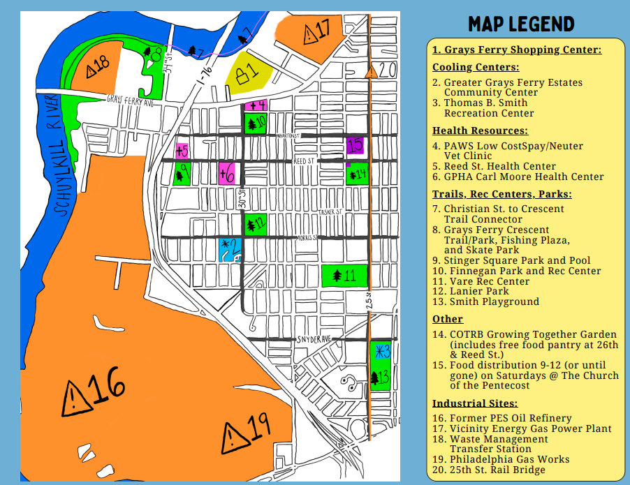
Grays Ferry Resource Map
This Community Map designed in partnership with Philly Thrive’s Mutual Aid Circle highlights local resources and greenspace as well as nearby industrial sites and pollution sources.
Local Air Quality and Pollution
Grays Ferry has been affected by pollution from local industrial sites for generations. Air pollution can enter your body and cause health issues, especially for children, elders, outdoor workers and people with underlying health conditions, like asthma. To learn more about the polluting sources closest to you, visit Clean Air Council’s Pollution Tracker here.
During poor air quality events you may experience symptoms like: Irritation, itching, swelling & watering of the eyes, irritation of the nose and throat, trouble breathing and chest tightness, coughing and wheezing, headaches and dizziness, and fatigue
To stay safe during poor air quality events you can: Check the weather and air quality daily, avoid the outdoors if possible, wear K95 or N95 Mask outdoors, keep inhalers and other medicine with you, stay well hydrated, use indoor air filters, close car windows and set AC to recirculate, and seek medical care if needed.
Clean Air Council has installed air monitors across South and Southwest Philly because air quality can vary between neighborhoods across the City due to local hazards. To see the current air quality in Grays Ferry visit the Purple Air Map here.
Extreme Heat:
Grays Ferry is much hotter than other parts of the city and temperatures on your block can be higher than what the news is reporting. These hot temperatures happen because pavement and buildings hold in more heat from the Sun, and car traffic and exhaust also add to the heat.
Climate change is causing higher temperatures and many large trees that provided shade in the neighborhood 30-60 years ago have been removed causing the neighborhood to become hotter. Extreme heat can be deadly and cause heat stroke and fatigue. Infants, young children, people with underlying health issues, and elders over the age of 65 are especially vulnerable to heat related illness.
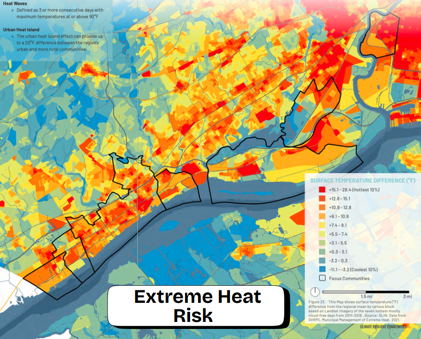
This map shows how the Grays Ferry area (the neighborhood outlined at the top right) is at a very high risk for heat exposure compared to other parts of the region:
To stay safe during extreme heat you can: Check the weather and the air quality for the day, find well-shaded places to rest like Stinger Square Park, reduce time outside during the hottest parts of the day (2-6pm), carry a water bottle and stay hydrated, take breaks in an air conditioned space, learn the symptoms of heat exhaustion and heat stroke, and visit the City’s Extreme Heat Guide: https://www.phila.gov/guides/extreme-heat-guide/
When extreme heat warnings are issued the City opens up Cooling Centers where you can access air conditioning. Visit the map to find a Cooling Center: https://experience.arcgis.com/experience/8d7b658a9fca4a78bac2c385d117a031
Restoring Shade to Cool the Neighborhood
Greenspace like parks, trails, and trees help to cool the neighborhood and reduce the impacts of rising temperatures. Using these resources you can apply for a free yard or street tree to help bring more shade to your block:
Get a Tree | Pennsylvania Horticultural Society
Request street tree maintenance: Tree-Related Services | City of Philadelphia
Become a volunteer Tree Tender to plant trees in your community, and join your neighborhood group: Tree Tenders Program | Pennsylvania Horticultural Society and Find a Tree Tenders Group Near Me