Clean Air Council has been engaged in an EPA funded air monitoring program in Delaware County and South and Southwest Philadelphia for about two and a half years now. In that time, Council staff have installed 60 purple air monitors and 8 high quality VOC sensors at private residences, churches, and municipal buildings across Marcus Hook, Trainer, Chester and surrounding areas in southern Delco, as well as throughout Grays Ferry, Eastwick, Kingsessing and surrounding areas in S/SW Philly. You can see all the Council’s Purple Air Monitors 24 hours a day at www.purpleair.com.
The data we have seen from these monitors over time paints a striking picture of air quality in the greater Philadelphia area:
1. Higher air quality readings occur in both Summer and Winter
2. Most days are in the moderate/yellow zone across our region, which exceeds air quality standards
3. The most significant poor air quality readings have been caused by the addition of wildfire smoke to our existing regional air quality challenges
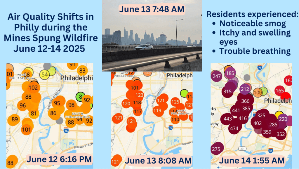
We’ve also seen a strong correlation between when residents are noticing odors or respiratory symptoms, and when the Purple Air particulate monitors or VOC sensors are spiking. For example, air quality reached hazardous levels from June 12th-14th 2025 when smoke from the Mines Spung Wildfire in New Jersey blanketed the region. Residents noted noticeable smog, trouble breathing, and itching and swelling eyes during this poor air quality event.
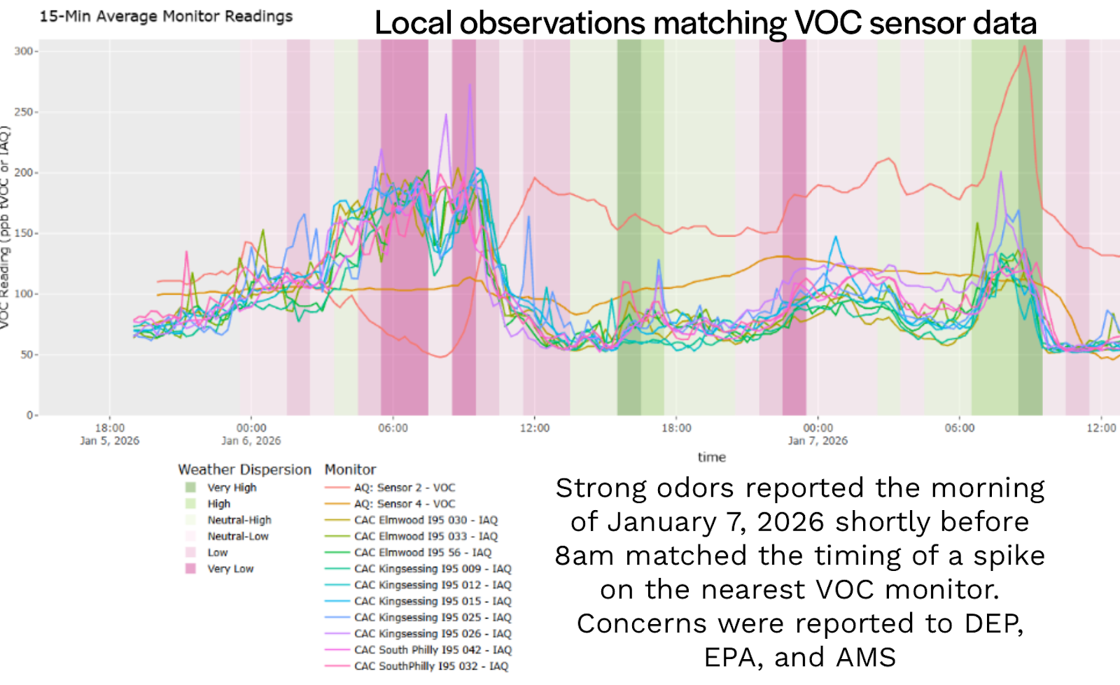
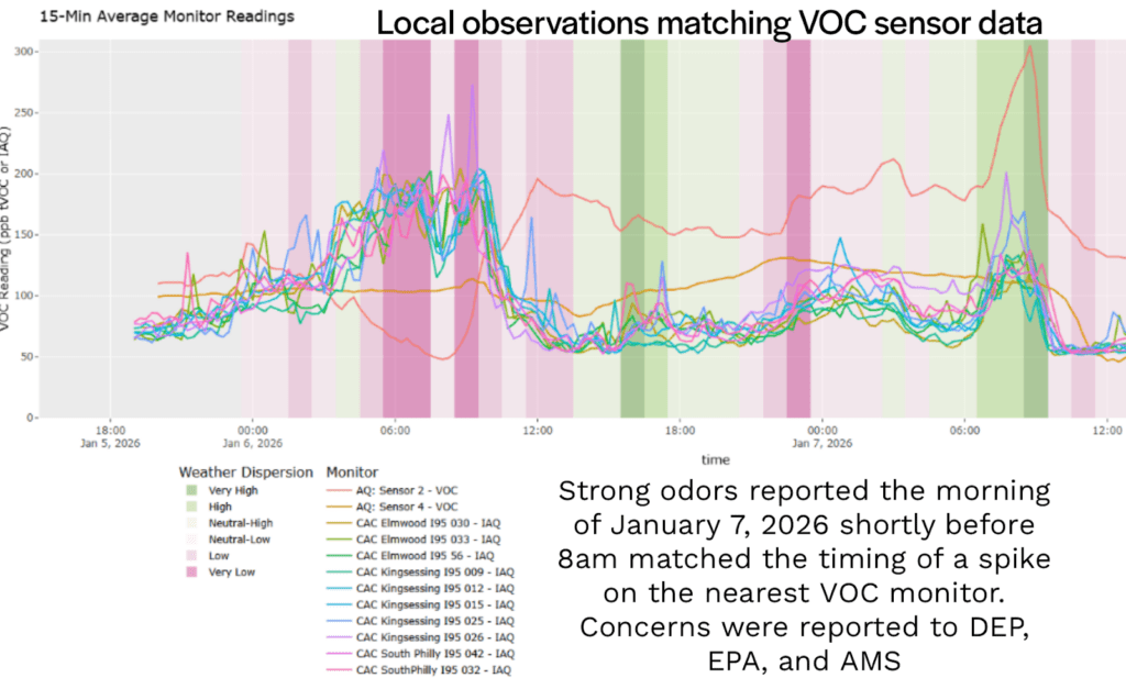
In January 2026, a resident reported a noxious odor in the Kingsessing/Cedar Park neighborhoods. The red line in this graph demonstrates how the nearest Volatile Organic Compound (VOC) sensor in Kingsessing spiked within the same time period, affirming resident reports on the ground.
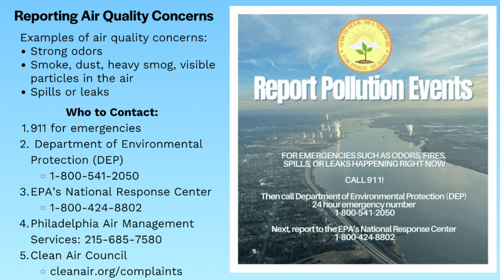
Residents can report air quality concerns as a simple but effective way to be an advocate for cleaner air. The more specific the information we have from impacted residents the better we can identify local pollution patterns, trends, and sources, as well as support ongoing advocacy. Residents who notice unusual and strong odors or visual signs of pollution, including, smoke, dust, heavy smog, or spills and leaks can report air quality issues to different governmental agencies.
In the case of an emergency, including strong odors, fires, spills or leaks, please call 911.
For these emergencies and other serious air pollution concerns, also call:
1. The Department of Environmental Protections (DEP) at 1-800-541-2050
2. The EPA’s National Response Center at 1-800-424-2050.
However, if you reside in Philadelphia, call the Philadelphia Air Management Services at 215-685-7580, instead of the EPA’s National Response Center. You can find more information at https://cleanair.org/complaints/.
Going forward, Council staff will continue to support our Community Air Monitoring network, including our network of incredible air monitor hosts. We hope to be able to use the data generated by our host monitors to inform advocacy efforts for cleaner, healthier air in the Philadelphia and Delaware County region.
If you would like to host a Purple Air monitor or VOC sensor, we have a few more to distribute in Delaware County. Contact Outreach Coordinator Alyssa Felix at afa@cleanair.org. You can also reach out to Advocate Russ Zerbo at rzerbo@cleanair.org any time you have air quality concerns. If you are a current air monitor host and have questions or concerns about your monitor, contact Community Organizer Jendaiya Hill at jhill@cleanair.org
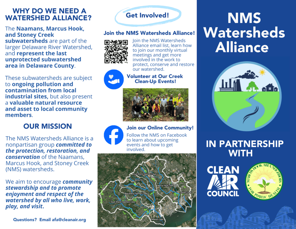
Clean Air Council and the Naamans, Marcus Hook, Stoney Creek (NMS) Watersheds Alliance are excited to announce the launch of the new NMS Watersheds Storymap! The storymap is an ArcGIS platform that shares the history, geography, and importance of the NMS Watersheds, as well as the story of the creation of the NMS Watersheds Alliance, and the accomplishments and goals of the group.
Take a Sneak Peak!
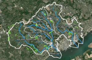
The Naamans Creek, Marcus Hook Creek, and Stoney Creek Watersheds
Naamans Creek, Marcus Hook Creek, and Stoney Creek (NMS) are part of the Delaware River Watershed and represent the last unprotected subwatershed area in Delaware County. The NMS watersheds are situated in and around the municipalities of Marcus Hook, Trainer, Upper and Lower Chichester, and Bethel Township.

Healthy watersheds are an essential foundation for healthy communities and ecosystems. These subwatersheds are a critical and valuable part of our local communities, but are also subject to ongoing pollution and contamination from local industrial sites. Petrochemical processing plants, refineries, tank farms, and other industrial facilities can leave behind legacy contaminants that persist in local ecosystems. Stormwater runoff can carry pollutants such as oil, gasoline, heavy metals, and other toxins that degrade water quality, harm local wildlife, and even impact drinking water. If left unaddressed, these issues can lead to further harm of the watershed, including reduced biodiversity and diminished access to the natural spaces that residents depend on for physical and mental well-being.
The Creation of the NMS Watersheds Alliance
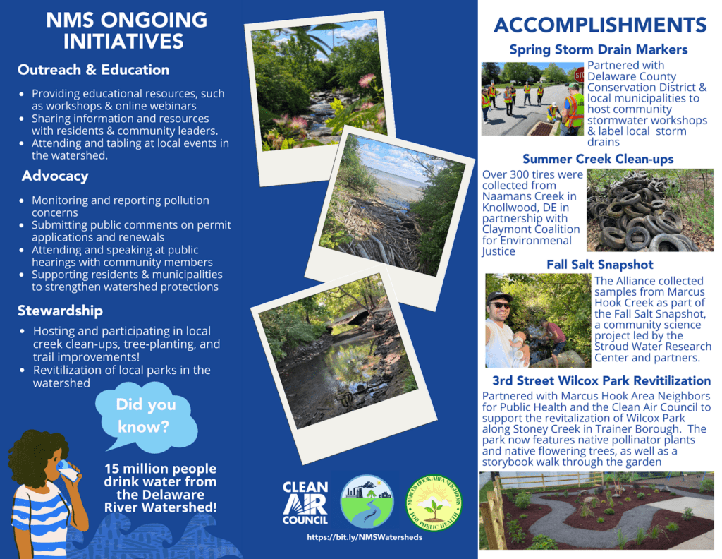
In 2024, with the support of the Clean Air Council and Marcus Hook Area Neighbors for Public Health, residents came together to develop a local watershed group to protect the NMS subwatershed areas. The NMS Watersheds Alliance is a nonpartisan group of residents committed to the protection, restoration, and conservation of the Naamans, Marcus Hook, and Stoney Creek (NMS) watersheds. The Alliance aims to encourage community stewardship and to promote connection, enjoyment, and respect of the watershed by all who live, work, play, and visit. NMS Watersheds Alliance initiatives address conservation, recreation, and water pollution issues in the watershed through outreach and education, advocacy, and stewardship.
Learn more about the NMS Watersheds Alliance by checking out our new brochure!
Introducing the NMS Watersheds Storymap
To tell the unique story of the NMS and virtually bring people into the watershed, the NMS Watersheds Alliance launched the Naamans, Marcus Hook and Stoney Creek Watersheds Alliance Storymap in early 2026. The creation of this storymap provides visualization of the watershed for residents and serves as an important tool for understanding our local water resources. The storymap details the history and geography of the NMS creeks, Delaware River Watershed, and pollution threats the NMS faces.
Residents can take a virtual tour of the watershed and learn more about the NMS Watersheds Alliance’s initiatives. This includes storm drain marking workshops, tree plantings, creek clean-ups, stream salinity testing, revitalization of local parks, advocating for the mitigation of pollution in our local streams, and more! The NMS Watersheds Alliance will regularly update the storymap with new projects, initiatives, and information about our creeks and watersheds. Check out the storymap to visit the NMS Watersheds virtually and learn more!
Get Involved with the NMS Watersheds Alliance! Follow us on Facebook to stay up to date, and if you’d like to join the NMS Watersheds Alliance’s monthly meetings, contact Alyssa Felix-Arreola at afa@cleanair.org.
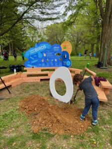
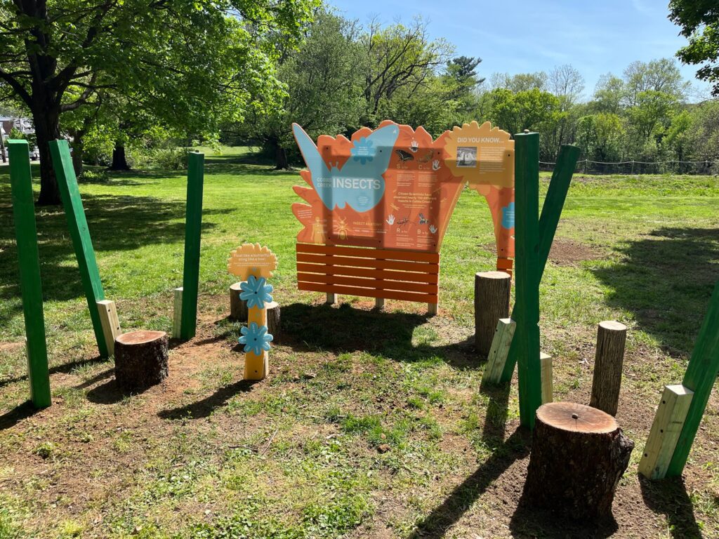
Clean Air Council is thrilled to announce we have been awarded the William Penn Foundations’ Investment in Public Parks Grant. This funding will allow the Council and community partners to expand the existing play and learning spaces at safe crossing entrances to Cobbs Creek Park. This project will transform park entrances to include mural art on the paved trail and areas for children and families to learn and play together.
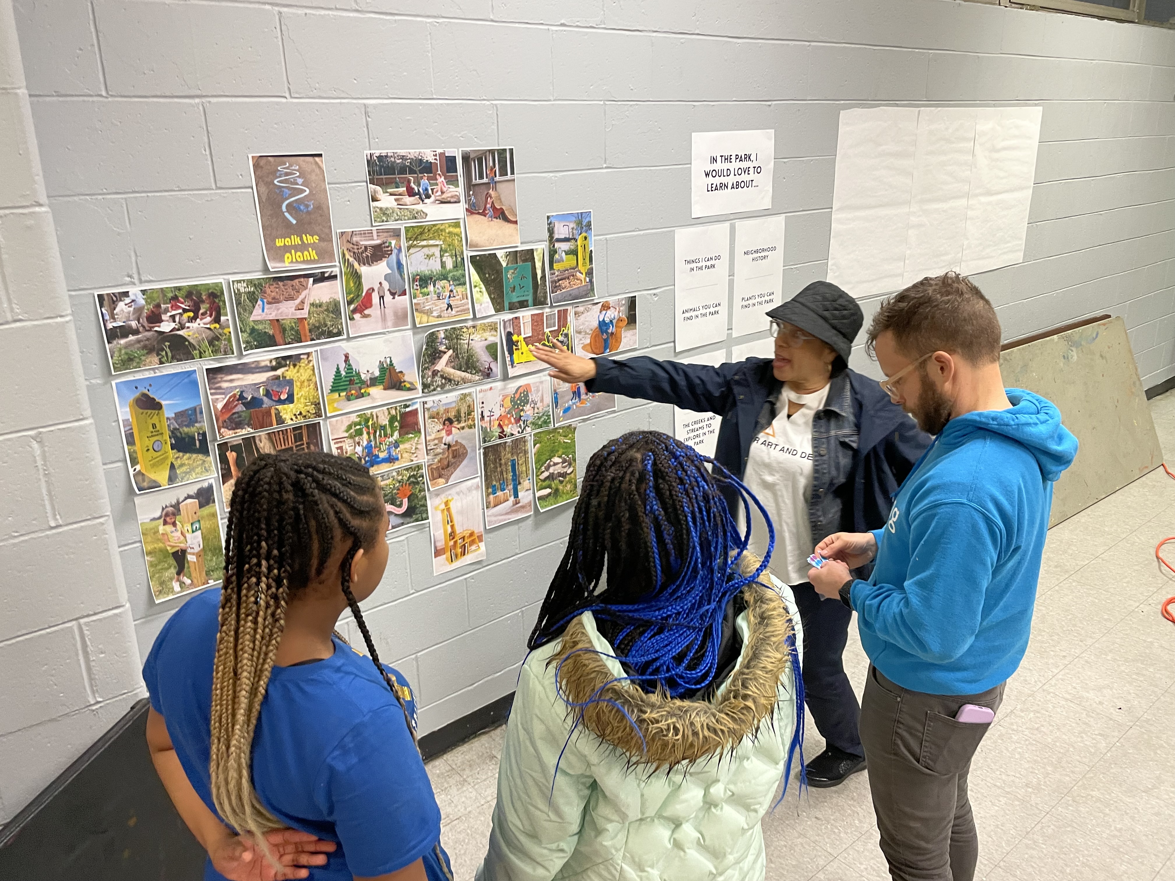
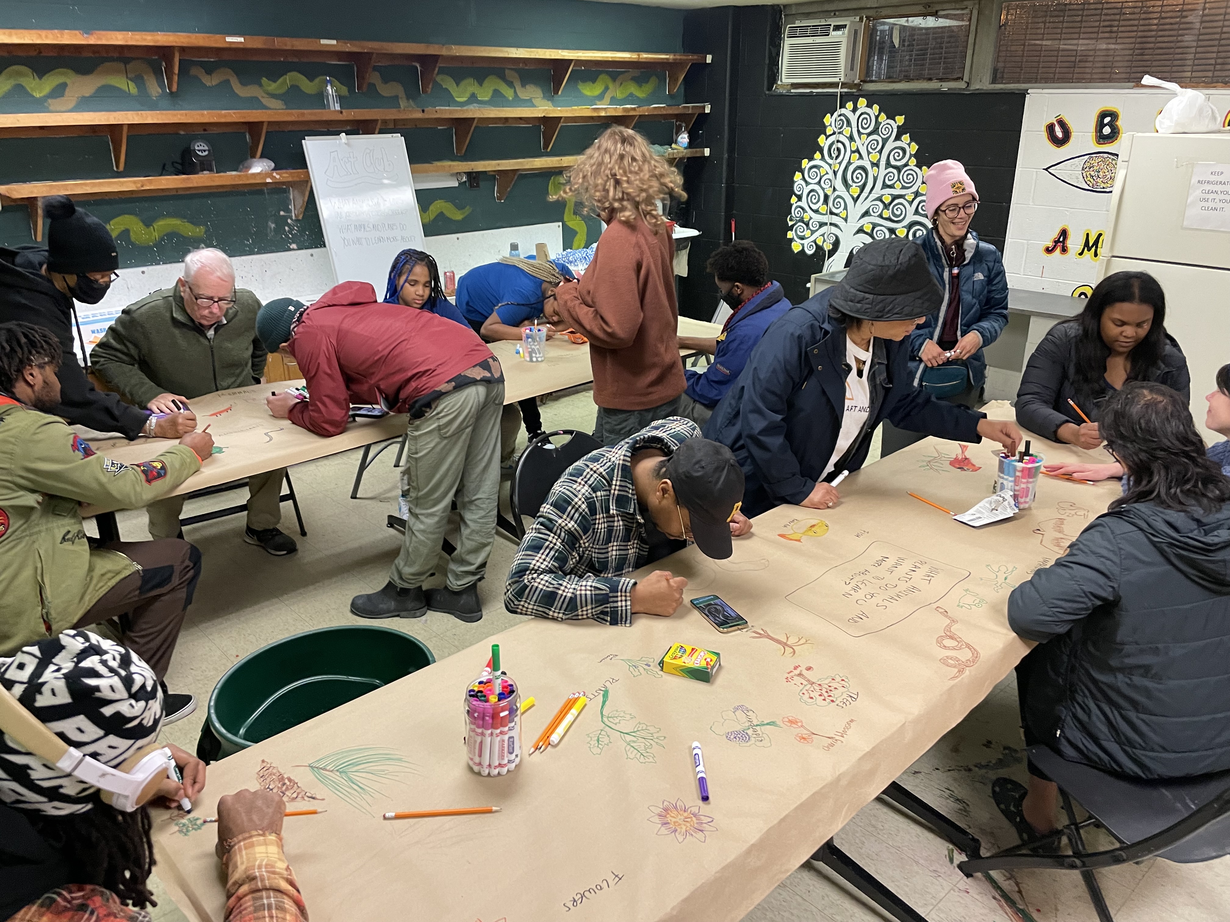
The Council has once again teamed up with Amber Art and Design and Tiny WPA to develop, design, and build art and play spaces in the vision of community members. Throughout the next several months we will be gaining inspiration and ideas from residents in order to guide the new play space designs. There are multiple opportunities for residents to inform the design and locations of the new little nature playgrounds including at in-person community design workshops, see details below.
1) February 10th 4-6:30pm at Cobbs Creek Community Environmental Center (700 Cobbs Creek Parkway).
2) April 7th 4-6pm at Paschalville Library (6942 Woodland Ave)
3) March 10th 5-7pm at Cobbs Creek Library (5800 Cobbs Creek Pkwy)
4) April 25th join us at Celebrate Trails Day 10AM-2PM for a final community feedback opportunity! (Thomas Ave and Cobbs Creek Parkway)

The project team has created a short survey as a starting place to learn more about what neighbors would like to see included in the design. We invite area neighbors and Cobbs Creek Park users to complete the survey and attend any and all of the workshops which will include an evening of creativity, story sharing, and imagination as we collectively envision and design mural art on trails and play areas for children and families.
Southbridge is a small, strong community in Southern Wilmington, Delaware with a rich history of civic activism, anchored by the Southbridge Civic Association and the Southbridge Community Development Corporation. This historically Black community is on the frontlines of industrial air pollution and rising seas, as well as riverfront development which is seriously impacting the neighborhood’s demographics and economics. With generous funding from the Wells Fargo Foundation, Clean Air Council worked to expand greenspace access in Southbridge, specifically advocating for the proper remediation and redevelopment of Barbara Hicks Park, which was found to be contaminated with dangerous heavy metals in 2022. In 2023, the Council helped Southbridge organizations and residents submit official public comments on the park’s remediation and redevelopment, but realized this was a more long-term effort. The Council worked with the Wells Fargo Foundation to secure funding for community outreach and greenspace enhancements, taking effect at the beginning of 2024.
Throughout 2024 and 2025, Council staff regularly appeared at Southbridge Civic Association meetings, discussing ways to improve the park’s redevelopment and raise awareness of its contamination. Council staff also helped neighbors engage with the Federal Highway Administration’s (FHWA) Wilmington Riverfront Transportation Infrastructure Project to make sure that all areas of South Wilmington saw significant local investments. Council staff provided a sample public comment that was submitted by several local residents and organizations. The FHWA responded to the Council’s comment about flooding and soil health in the area saying, “two feet of clean fill cap will be used to prevent contaminated soil erosion and human contact.” This statement would later be used by local leaders in a meeting with the City of Wilmington in Fall 2025, leading to a more protective cleanup of Barbara Hicks Park. The City’s original plan for the park was uncertain and did not commit to any firm plans for soil removal or the placement of clean soil but, after this meeting, it committed to the removal of two feet of contaminated soil and the placement of two feet of clean soil. Wilmington also expanded Hicks Park, eliminated mosquito-ridden standing water, and committed to adding new amenities, like exercise and playground equipment, which local organizations had been advocating for since at least 2017.
Funding from the Wells Fargo Foundation additionally supported Southbridge Day in August 2024, turning Elbert Playground into an adventurescape complete with moonbounces, a dunk tank, an ice cream truck, face painting and a photo booth. Wells Fargo Foundation funding also supported the distribution of hundreds of book bags to local young people, additionally supporting local retailer Carry My Own Weight. Southbridge Day 2024 was a beautiful celebration of what could be possible with safe local greenspaces, leading to increased communications with the City of Wilmington and firm plans to remediate and renovate Hicks Park. Council also used project funding to support the Delaware Nature Society’s native planting at Mille Cannon Park.
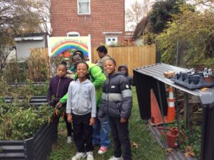
Council staff also worked to support the Southbridge Community Garden, a greenspace in the center of Southbridge where owner Wayne Marshall grows vegetables to distribute locally. Funding from the Wells Fargo Foundation helped Wayne fix his fence to prevent a neighboring dog from scaring local kids visiting the garden. Funding also helped Wayne create an outdoor kitchen and construct a pavilion with the help of a local Black-owned construction company. This project’s funding helped Wayne acquire a leaf blower and a pole saw to help maintain the garden and keep his neighborhood clean, as well as an electric generator to bring power to the garden.
We celebrated the conclusion of this project in November 2025, when peppers were still growing in the Southbridge Community Garden! Watch the short videos below:
Did you make energy efficiency upgrades or buy an electric vehicle last year? This tax season, our tool can help you identify tax-credit-eligible purchases. Download the PDF to access the links in the tool.
This resource toolkit was created by Grace Brigham (she/her), a senior Bachelor of Social Work student (class of ‘25) with a minor in Environmental Studies at Temple University, to provide a comprehensive compilation of information about flooding and heat in Philadelphia for those affected. She reviewed a series of reports about climate change in Philadelphia and mitigation strategies for heat and flooding available in the city to produce a website page that covers all of the fundamental information a reader might want to know about flooding and heat.
Grace firmly believes that environmental justice is essential for fostering healthy, thriving communities and is deeply passionate about advocating for and supporting underserved and vulnerable populations. She created this toolkit largely due to responses collected from attendees of Clean Air Council community meetings who requested more information about heat and flooding and what they could do in their homes and communities to make change. This web page is designed so that if the reader already knows certain information or is only looking for information from a specific section, they can jump around to a particular section and still get all the information they are looking for.
Phrases in bold will be defined at the end of this document. You can reach Grace with any questions at grace.brigham@temple.edu.
Climate Change Impact on Philadelphia
Philadelphia is a heavily industrialized city, with an estimated 72% of the city composed of impervious surfaces (Delaware Watershed – Philadelphia Water Department). As the effects of climate change continue to increase, the city faces more frequent extreme flooding and heat events. Climate is the long-term, average weather conditions in a specific area, whereas weather is a specific event that occurs over a short period of time and changes day to day, or over a series of days. Climate change refers to the change in average weather over a long period of time–more specifically, a warming of temperatures. Some of the climate change impacts that the city of Philadelphia is facing, and will continue to face, are increased precipitation, rising river and sea levels, and increased temperatures.
Increased Precipitation Numbers:
Since the 1940s, Philadelphia’s annual average precipitation has increased 0.82 inches per decade (about 6.5 inches in total) (A Climate Resilience Research Agenda for the Greater Philadelphia Area 8)
Philadelphia’s average annual precipitation is estimated to increase up to 12 percent by the 2050s and up to 16 percent by the 2080s (A Climate Resilience Research Agenda for the Greater Philadelphia Area 8)
Philadelphia’s total annual precipitation was 44 inches between 1950 and 1999. It is estimated to increase up to 49 inches by the 2050s and up to 50 inches by 2100 (City of Philadelphia 2022 All Hazard Mitigation Plan Update 145)
Rising River and Sea Level Numbers:
“Sea level is projected to rise in Philadelphia [to] 7 to 11 inches by the 2030s, 14 to 19 inches by the 2050s, and 24 to 38 inches by the 2080s” (A Climate Resilience Research Agenda for the Greater Philadelphia Area 8)
“[T]he tidal Delaware River rose at the rate of about 1.2 inches per decade over the last century” (A Climate Resilience Research Agenda for the Greater Philadelphia Area 8)
Increased Temperature Numbers:

“Over the past 82 years, annual average temperature has increased at a rate of 0.43 ℉ per decade. In the observed record at Philadelphia International Airport, 8 of the 10 hottest years on record have occurred since 2000” (A Climate Resilience Research Agenda for the Greater Philadelphia Area 9)
The five hottest years recorded in Philadelphia have all occurred since 2012 (Annual Top 10 for Climate Sites)
Philadelphia’s average annual temperatures are estimated to increase up to 5.8 ℉ by the 2050s and up to 9.4 ℉ by the 2080s (A Climate Resilience Research Agenda for the Greater Philadelphia Area 9)
As of 2021, there was an average of 6 days per year with maximum temperatures at or above 95 ℉. This number is estimated to range from 21 to 34 days per year by the 2050s and 34 to 72 days per year by the 2080s (A Climate Resilience Research Agenda for the Greater Philadelphia Area 9)
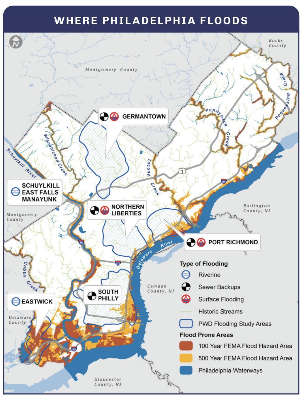
Flooding in Philadelphia
According to the Office of Emergency Management, Pennsylvania has the highest flooding rate of any state in the United States (Flood | Office of Emergency Management | City of Philadelphia), and Southeastern Pennsylvania is one of the most flood-prone regions of the state. As Philadelphia is built between two tidal rivers, the Delaware River and the Schuylkill River, flooding is a major concern for Philadelphians.
Why is Philadelphia Flooding?
“Because Philadelphia is located at the lower end of major watersheds, it is particularly susceptible to flooding when heavy rainfall accumulates as it flows downstream, leading to higher and faster flowing floodwaters” (City of Philadelphia 2022 All Hazard Mitigation Plan Update 131)
“Densely populated areas have a high risk for flash floods, as the construction of buildings, highways, driveways, and parking lots increases runoff by reducing the amount of rain absorbed by the ground… Flash flooding may also lead to localized, overwhelmed sewer systems and basement backups [through] basement fixtures and drains” (City of Philadelphia 2022 All Hazard Mitigation Plan Update 132)
“Philadelphia’s sewer system was originally designed and built in the late 1800s and early 1900s. Since then, the amount of impervious area in the city has drastically increased… Rain that used to soak into the ground now quickly runs across impervious surfaces and into the sewer system. When large amounts of precipitation fall over a small area in a short period of time, this can overwhelm the sewer system and [cause] localized surface flooding” (City of Philadelphia 2022 All Hazard Mitigation Plan Update 132)
“Philadelphia’s combined sewer system serves about 60 percent of the city. During wet weather, this older section of our system often overflows. As a result, billions of gallons of stormwater and diluted sewage flow into local waterways each year” (Green City Clean Waters – Philadelphia Water Department)
Where is Philadelphia Flooding?
Two communities in Philadelphia, Eastwick and Manayunk, are located in high-risk flood zones.
“Eastwick was constructed on the Tinicum marsh, the confluence of the Schuylkill, Darby Creek, and Cobbs Creek (City of Philadelphia 2022 All Hazard Mitigation Plan Update 132)
“Flooding in Manayunk along Main Street is the result of the rising Schuylkill River which can be exacerbated by severe storms” (City of Philadelphia 2022 All Hazard Mitigation Plan Update 133)
Heat in Philadelphia
With an estimated 72% of Philadelphia covered by impervious surfaces (Delaware Watershed – Philadelphia Water Department), the city heats up rapidly and is unable to cool down at the same rate. Climate change, combined with a lack of green space, is leading to longer and hotter extreme heat events.
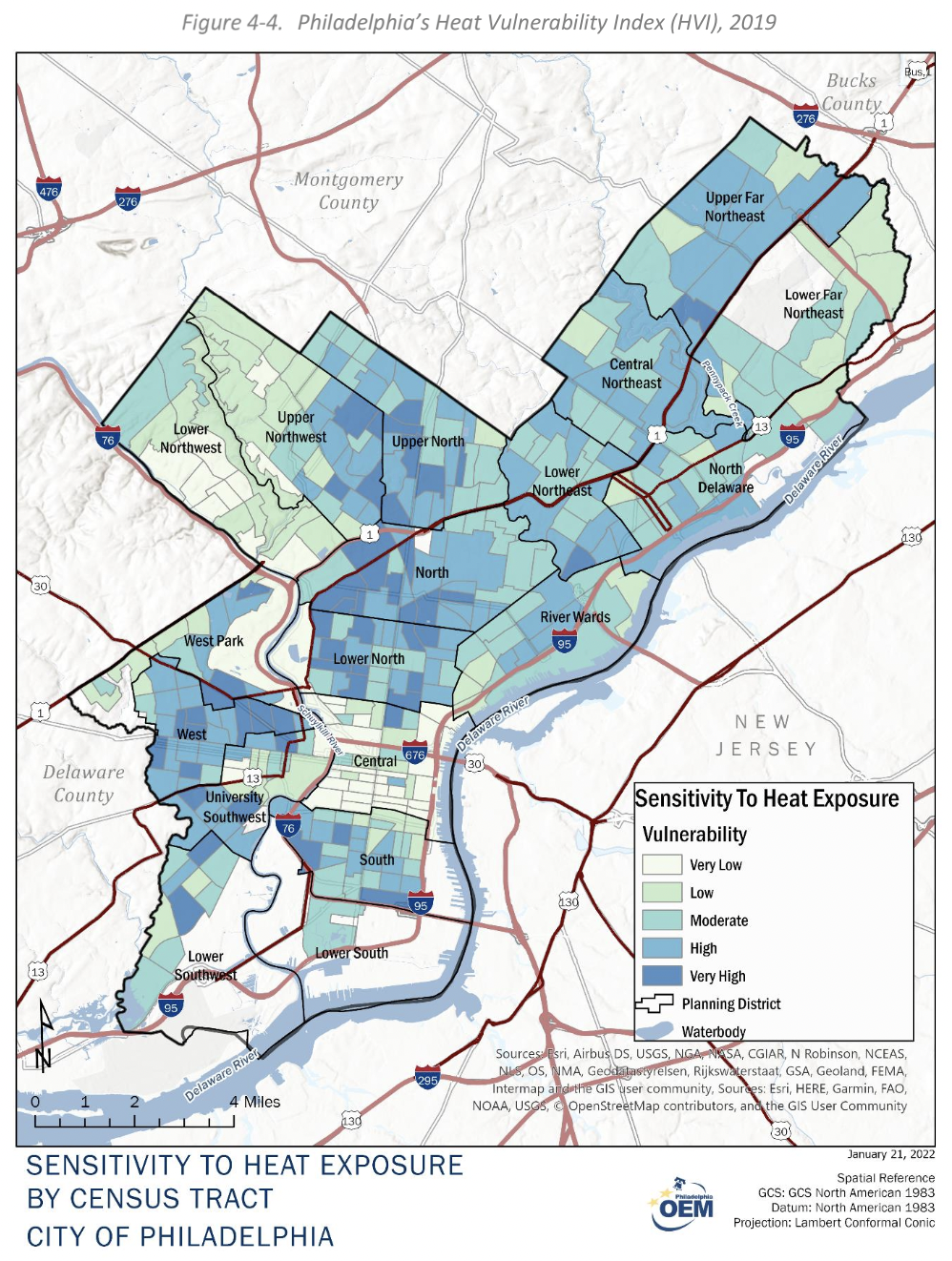
Urban Heat Island Effect
“Philadelphia has less green space than surrounding suburban areas and more paved surfaces which absorb heat faster and release heat slower than green space… Dry, impervious surfaces like asphalt may continue to release heat hours after the sun is down. Other urban by-products, such as exhaust fumes, burning furnaces, [cooling] units, and smokestacks also contribute to heat retention and entrapment and reduce air quality during hot weather” (City of Philadelphia 2022 All Hazard Mitigation Plan Update 122)
“The strength of the heat island effect also varies across the city and is based on factors in the built environment like number of street trees, proximity to highways or industry, and the presence of green space like parkland. This means that while the entire city is subject to higher heat compared to outlying parts of the region, some neighborhoods are even more vulnerable than others” (City of Philadelphia 2022 All Hazard Mitigation Plan Update 123)
Why is Extreme Heat Dangerous?
“Extreme heat often results in the highest number of annual deaths of all weather-related hazards” (City of Philadelphia 2022 All Hazard Mitigation Plan Update 122)
Environmental Injustice in Philadelphia
While climate change is affecting the entire city, increased flooding and heat affect certain areas of the city at a disproportionately high rate due to factors such as flood zone property development, decrease in tree cover, and redlining.
Flood Zone Development
Many low-income communities of color, like Eastwick, face flooding challenges due to their proximity to waterways and lack of infrastructure to protect themselves from rising sea levels and increased inland flooding (As Waters Rise, a Community Must Decide: Do We Stay or Go? – Yale E360)
“According to Risk Factor, a tool created by the climate-information nonprofit First Street Foundation, 89 percent of Eastwick properties face a “severe” risk of flooding in the next 30 years” (As Waters Rise, a Community Must Decide: Do We Stay or Go? – Yale E360)
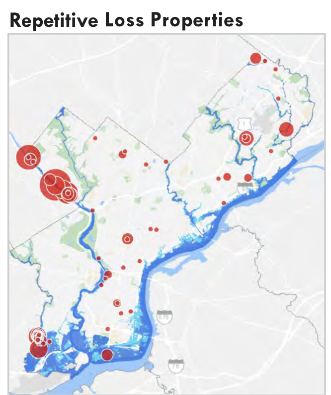
“Repetitive loss properties are structures insured under the NFIP [National Flood Insurance Program] which have had at least two paid flood losses of more than $1,000 over any ten-year period since 1978. According to PEMA [Pennsylvania Emergency Management Agency] data pulled in November 2021, there are 126 repetitive loss properties in Philadelphia” (City of Philadelphia 2022 All Hazard Mitigation Plan Update 142)
Two landfills near Eastwick make up the Lower Darby Creek Area Superfund Site. Flooding in this area not only poses risks of property damage but also poses health risks by spreading contaminants into the communities and homes of affected residents.
Decrease in Tree Cover
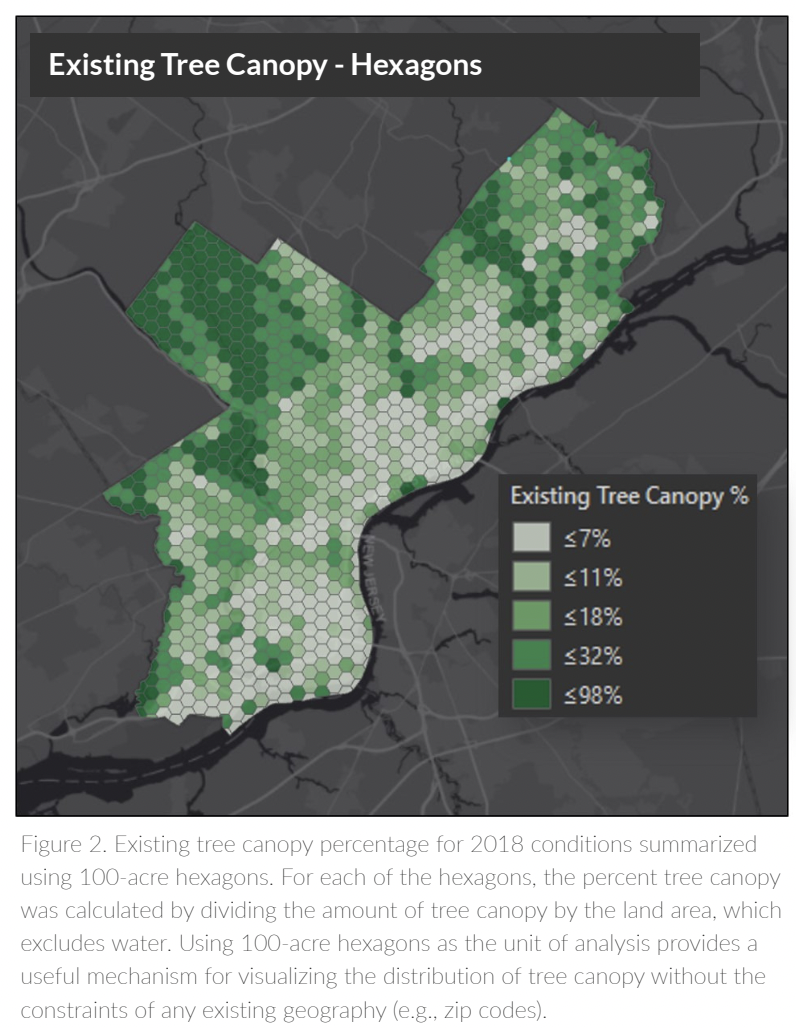
“[B]etween 2008 and 2018, Philadelphia’s urban forest shrunk by 6%. That’s equal to 1,000 football fields worth of tree canopy. And the tree canopy we do have is not fairly distributed across the city. Some neighborhoods have under 5% tree canopy, and others have 45% or more” (Philly Tree Plan Executive Summary 1)
“There is a 22-degree difference between the hottest and the coolest places in Philly” (Philly Tree Plan Executive Summary 2)
“The densely urbanized and industrialized areas, particularly those in Center City and along the Delaware River, have strikingly low amounts of tree canopy and therefore experience the negative impacts, such as increased heat” (Philadelphia Tree Canopy Assessment 2018 6)
Redlining in Philadelphia
“Redlining is a historical form of institutional racism that contributes to present-day racial residential segregation, a fundamental cause of racial disparities in health and neighborhood environments. Redlining refers to maps that the federally sponsored Home Owners’ Loan Corporation (HOLC) created in the early 1930s, for cities across the USA. During the new deal era and following the Great Depression, when the USA was in the midst of a foreclosure crisis, the HOLC issued loans to help homeowners avoid losing their homes, or to reacquire their already-lost homes” (Associations Between Historical Redlining and Present-Day Heat Vulnerability Housing and Land Cover Characteristics in Philadelphia, PA)
“The HOLC assessed the so-called riskiness of borrowers, and thus their willingness to issue loans, by creating maps that delineated neighborhoods into the following grades: A, or most desirable (color = green); B, slightly less desirable (color = blue); C, declining neighborhoods (color = yellow); D, undesirable (color = red). These grades were assigned, in large part, based on the neighborhood’s sociodemographic composition, and areas with high percentages [of] low-income immigrant or Black residents received a grade D rating”
“In the first study to examine historic redlining practices and contemporary measures of housing heat vulnerability in a major city in the USA, we found that higher proportions of properties in HOLC grade B, C, and D neighborhoods had low or no tree canopy, lacked immature street trees, and had more dark, flat roofs, compared to properties in HOLC grade A neighborhoods”
Social Vulnerability
In the context of climate and weather-related issues, “[s]ocial vulnerability is the susceptibility of an individual or social group to the negative impacts of natural hazards and disasters due to characteristics that influence one’s ability to prepare, respond, cope, or recover from a disaster” (City of Philadelphia 2022 All Hazard Mitigation Plan Update 46)
Vulnerability is broken into three parts:
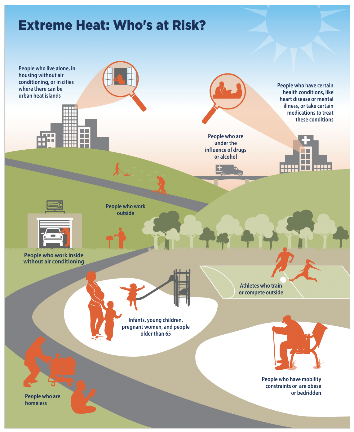
1. Exposure: “Some people are more exposed to high temperatures than others, such as those who spend long hours working or exercising outside, those who are homeless, or those who live in buildings without air conditioning” (Climate Change and Extreme Heat: What You Can Do to Prepare 12)
2. Sensitivity: “Some people are less tolerant of heat than others, such as infants, young children, pregnant women, older adults, and those with certain health conditions made worse by heat exposure” (Climate Change and Extreme Heat: What You Can Do to Prepare 12)
3. Adaptive Capacity: “Some people are less able to avoid heat than others, such as those with limited incomes who cannot afford air conditioning or the electricity to use it, people with mobility issues that prevent them from seeking health care or going to a cooling center during a heat wave, or those with outdoor jobs” (Climate Change and Extreme Heat: What You Can Do to Prepare 12)
Populations vulnerable to heat:
Individuals 65 and older (13.4% of the Philadelphia population)
Children 5 and younger (6.6% of the Philadelphia population)
Individuals who are pregnant
Individuals with a physical illness or pre-existing conditions (e.g., heart disease or high blood pressure)
Individuals who are using alcohol or drugs
Low-income individuals who do not have access to proper cooling (e.g. limited access to air conditioning)
Individuals living without adequate shelter
Individuals with limited access to healthcare
Individuals who work or exercise outside
Individuals who work inside without air conditioning
Individuals living below the poverty line (23.3% of the Philadelphia population)
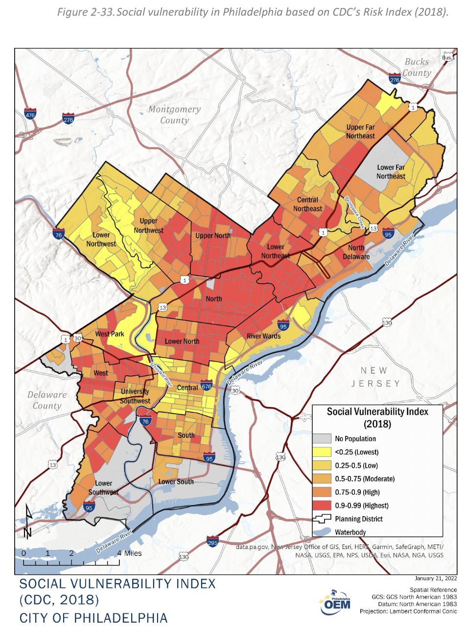
Heat Vulnerability Index: “The Philadelphia Heat Vulnerability Index shows the areas in the city that are most at-risk of experiencing heat-related illnesses during very hot weather. A block is more vulnerable if it is both very hot and if the people who live there are more sensitive to higher temperatures, like older folks and people with certain chronic medical conditions”
Environmental Benefits of Green Space
Beyond directly impacting heat and flooding by lessening their intensity, trees and other greenspaces offer significant benefits to local communities by actively combatting climate change.
What are the Benefits of Trees and Greenspace?
“Philadelphia’s urban forest stores an estimated 2.6 million tons of carbon dioxide (a primary greenhouse gas) and removes and stores an additional 99,000 tons of carbon dioxide per year” (Philly Tree Plan Executive Summary 2)
One of the Philly Tree Plan’s goals is to reach 30% tree cover across different land units, including street trees, residential yards, commercial and industrial areas, campuses and schools, city facilities, and public facilities, neighborhood parks by the year 2050 (Philly Tree Plan 32). If this goal is accomplished, environmental benefits would include:
400 premature deaths avoided per year
1,000 full-time jobs
$20 million per year in combined environmental benefits (i.e., reduced air pollution, carbon sequestration, reduction in residential energy consumption, and stormwater management)
12% reduction in crime
Green stormwater infrastructure, which is vegetation that combats flooding by absorbing stormwater, also reduces carbon dioxide and filters out pollutants to improve air quality (Green City Clean Waters – Philadelphia Water Department)
“Trees shade humans and buildings, saving energy that would be used for air conditioning and reducing the heat island impact” (Green City Clean Waters – Philadelphia Water Department)
Other Information
EJScreen: The EJScreen (Environmental Justice Screen) is a useful tool created by the Environmental Protection Agency designed to provide data on areas with environmental burdens and vulnerable populations, such as flood risk, 100 year floodplain, and extreme heat. This allows individuals to enter their address or community and explore the environmental vulnerabilities, health vulnerabilities, and socioeconomic indicators in their areas in comparison to their state or the country.
Philadelphia Climate Action Playbook Executive Summary: Explore the City’s official climate initiatives
Flood Resilience in Philadelphia
As flooding becomes more frequent in Philadelphia due to the increased effects of climate change and increased impervious development, flood resilience becomes increasingly necessary to mitigate the negative impacts of flooding. What resources exist for individuals and communities to prepare for flooding?
What Programs Exist?
Flood Risk Management Task Force | City of Philadelphia: The Flood Risk Management Task Force (FRMTF) works to: Protect communities from flood risk, advance climate adaptation, ensure smart infrastructure and land use decisions, and build collaboration among City agencies around flood risk management. Their work includes projects in mapping and risk assessment, mitigation planning, and engagement and advocacy. If your community is working on a flood resilience project or is interested in starting one, email Elaine.Montes@phila.gov for available resources.
Green City Clean Waters – Philadelphia Water Department: “[A] 25-year plan [2011-2036] to reduce the volume of stormwater entering combined sewers using green infrastructure and to expand stormwater treatment capacity with traditional infrastructure improvements”
The National Flood Insurance Program: Allows property owners to purchase federally-backed flood insurance.
READYHome Personal and Family Preparedness Workshops | Office of Emergency Management | City of Philadelphia: “With our READYHome workshops, everyday people will receive easy-to-follow tips on how to come up with an emergency plan. The length of this workshop is approximately one hour. This is a great workshop for all community groups. These plans include family members with disabilities, for pets, and how to shelter in place.” Families and groups can schedule a workshop.
Flood Preparedness Actions
Actions for Individuals:
What to Do Before a Flood:
Checklist to Prepare for a Flood and Minimize Loss
Know your federally defined flood risk:
Buy flood insurance:
Flood Insurance Manuals and Handbooks | FEMA.gov
NFIP Flood Insurance for Renters Brochure: Flood insurance for renters
Flood Insurance Providers | FloodSmart
Keep in mind that flood insurance policies do not automatically renew and need to be renewed every year.
Understanding Flood Loss Avoidance
Make a claim to receive financial support:
“When flooding is imminent or predicted, National Flood Insurance Program (NFIP) policyholders are eligible to receive up to $1,000 to purchase loss avoidance supplies like tarps, sandbags, and more” (What to Do Before a Flood)
Take a household inventory (pictures and videos) of all important household items, such as furniture and valuables. These documents will be important when filing an insurance claim. Store important documents (e.g., birth certificates, passports, medical records, and insurance papers) in a safe, dry place.
An Eastwick Resident’s Guide to a Flood Ready Home
Use this tool to identify your home type, which is “the design, layout, construction material, and location of your home. These things matter because the design of your home changes both the vulnerabilities to flooding and the Flood Ready Home Strategies that are possible” (8)
Match flood-ready home strategies to your home type
Install free and reduced-cost stormwater management tools: Rain Check – Philadelphia
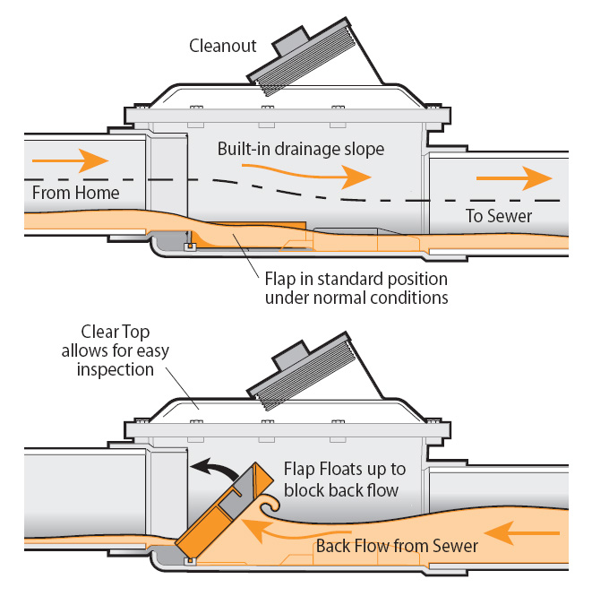
Install a free backwater valve and receive a free downspout modification. Backwater valves allow wastewater to leave the residence but prevent water from reentering the pipes. Downspout modifications may be helpful if water from a roof’s gutter is flowing back through the pipes: Basement Backup Protection Program | City of Philadelphia
Explore Flood Mitigation Home Improvements for flood mitigation home improvements to implement before a flood:
Install backwater valves through the Basement Backup Protection Program (18)
Remove basement plumbing fixtures (21)
Inspect lateral pipes (18)
Determine if you qualify for a Homeowner’s Emergency Loan Program (HELP) for repairs to water service lines (18)
Seal cracks, use a sump pump, and slope ground (19)
Identify where you can capture and divert stormwater (19)
Install a window well (19)
Clear storm drains of debris (20)
Clean your gutters regularly (20)
Ensure proper downspout placement and roof drainage through the Basement Backup Protection Program (20)
Install a rain barrel or downspout planter with Rain Check (20)
Install a diversion trench in your driveway to redirect rainwater (21)
Hire a contractor to install barriers at property and driveway entrances (21)
Stack sandbags at property entrances (21)
Explore Flood Mitigation Home Improvements for action steps to take after a flood:
Turn off the electricity to the affected area (22)
Discard all medicine and food in contact with floodwater (22)
Do not allow children to touch wet items until they have been disinfected (22)
Remove all standing water by pumping, mopping, and opening clogged drains (23)
Open windows and use fans and/or dehumidifiers for at least 24 hours after cleaning (23)
Clean and dry wet light fixtures before turning on electricity (23)
Actions for Communities
Establish a Community Flood Group to engage the community on local flood risk and proactive emergency planning: A Guide to Forming a Flood Group
Receive grants to clean and monitor green stormwater infrastructure sites: Soak It Up Adoption
“The Community Rating System (CRS) is a voluntary incentive program that recognizes and encourages community floodplain management practices that exceed the minimum requirements of the National Flood Insurance Program (NFIP).” Apply to become a Community Rating System community: Community Rating System | FEMA.gov
“In CRS communities, flood insurance premium rates are discounted to reflect the reduced flood risk resulting from the community’s efforts that address the three goals of the program:
1. Reduce and avoid flood damage to insurable property
2. Strengthen and support the insurance aspects of the National Flood Insurance Program
3. Foster comprehensive floodplain management”
Other Information
Basement Flood Mitigation: How you can protect yourself from property damage and loss
Building Resilient Infrastructure and Communities (BRIC) | FEMA.gov: Communities can apply to receive funding for flood resilience initiatives
FEMA Protect Your Property From Flooding: Flood resilience improvements inside and outside of the home
Flood Resiliency in Eastwick: New FEMA Funding & Other Progress: Eastwick Building Resilient Infrastructure and Communities (BRIC) success story
Homeowner’s Stormwater Handbook: Greening flood improvements for homeowners
Household Guide to Resources for Flooding in Philadelphia: Detailed flood preparation action list
Registered Community Organizations (RCOs) | City of Philadelphia: How to create an RCO or find an existing group concerned with planning and advocacy for their community
OpenMaps | phila.gov: Find your RCO by selecting “Registered Community Organizations (RCO)” in the filter section
Severe Weather Safety Guide: How to make an emergency go-bag in case of a flood
Heat Resilience in Philadelphia
As Philadelphia faces skyrocketing temperatures, largely due to an overabundance of industrialization and limited greenspace, residents’ health and safety become more and more pressing. What resources exist for individuals and communities to cool down?
What Programs Exist?
Code Red: The City of Philadelphia Office of Homeless Services allows unhoused individuals to stay in city-funded shelters during the day and sends outreach teams to provide information on daytime homeless service program locations
Emergency Systems Repair Program: Homeowners can receive free repairs for electrical, plumbing, heating, structural, and roofing emergencies
Low Income Home Energy Assistance Program (LIHEAP) | Benefits.gov: Federal program that assists low-income individuals with their energy bills
Neighborhood Energy Centers: Locations across Philadelphia where residents can apply for bill payment assistance, learn how to conserve water, gas, and electricity, and get energy counseling”
PECO Customer Assistance Program: PECO program that provides customers with a fixed monthly bill according to their household income
Pennsylvania Homeowners Assistance Fund : A program that provides funds for eligible homeowners who need assistance paying their water, electric, gas, and sewer bills
Philly Tree Plan: A program whose goal is reaching 30% tree canopy cover across Philadelphia by 2050
ReadyPhiladelphia | City of Philadelphia: The City of Philadelphia’s emergency and weather notification system, which can be targeted to specific locations
Utility Grant Program: “[Utility Emergency Services Fund] provides financial assistance to low-income individuals and families who are facing utility terminations or who have had their utilities shut off. PECO and the Philadelphia Water Department match each dollar we provide.” Explore the program’s neighborhood intake sites.
Heat Resilience Actions
Actions for Individuals
Apply for a free yard or street tree:
Get a Tree | Pennsylvania Horticultural Society
Tree-Related Services | City of Philadelphia
Request street tree maintenance:
Tree-Related Services | City of Philadelphia
Receive tree planting and maintenance training, become a volunteer Tree Tender to plant trees in your community, and join your neighborhood group:
Tree Tenders Program | Pennsylvania Horticultural Society
Find a Tree Tenders Group Near Me
Actions for Communities
Establish a Community Heat Team to develop heat mitigation and management strategies:
Beat the Heat Toolkit | City of Philadelphia
Beat the Heat Hunting Park: Steps to establish team (48-49)
Establish a community greening plan to implement more green infrastructure in your neighborhood:
Enhancing Sustainable Communities with Green Infrastructure (EPA)
Greening Plan Example – Nicetown and Tioga
Other Information
Extreme Heat Guide | City of Philadelphia: City of Philadelphia’s guide to extreme heat health and safety information and resources
Philadelphia Cooling Centers: Map of cooling centers in Philadelphia
Philadelphia More Beautiful Committee | Programs and initiatives: Find your clean block captain working to keep your neighborhood clean and green
Registered Community Organizations (RCOs) | City of Philadelphia: How to create a community development group or find an existing group
OpenMaps | phila.gov: Find your RCO by selecting “Registered Community Organizations (RCO)” in the filter section
Summer Heat Fact Sheets: Information for individuals who are part of a heat-vulnerable group
Local Action and Groups
City of Philadelphia | Eastwick: From Recovery to Resilience: “Initiative by the Office of Sustainability to address flooding, environmental justice, and quality of life challenges in Eastwick”
City of Philadelphia | Report an Environmental Justice Concern: Report an environmental or health hazard in your community to be investigated by the Department of Public Health
City of Philadelphia | Tree-Related Services: Access services related to obtaining or maintaining street and yard trees
Clean Air Council: The Clean Air Council is an environmental nonprofit dedicated to protecting the right to a healthy environment through sustainability and public health initiatives.
Darby Creek Valley Association: “[N]onprofit watershed organization dedicated to the protection and enhancement of the Darby Creek Watershed and its resources”
Delaware Valley Regional Planning Commission | Pennsylvania Coastal Resiliency: The Delaware Valley Regional Planning Commission is an advisory agency for sustainable planning in the Greater Philadelphia region. Explore their Pennsylvania Coastal Resiliency page, “a general resource for communities, especially those located on or near tidal waterways that are working to address flooding from sea level rise, storm surge, stormwater runoff, and/or riveting flooding”
Eastwick United CDC: “We are residents of the Eastwick, united in a common goal to improve the quality of life for members of the Eastwick community”
Federation of Neighborhood Centers Inc. | Community Learning Farm: “The Community Learning Farm at 8th and Poplar supports our neighbors across Philadelphia in their efforts to grow their own food, access quality local produce at all price points, and engage mindfully with the natural environment”
Neighborhood Gardens Trust: “We are a land trust dedicated to preserving and supporting community gardens and other shared open spaces across the city”
Office of Sustainability | Beat the Heat Hunting Park: Toolkit created through a partnership between the Office of Sustainability and neighborhood groups in Hunting Park to create resources for building local climate resilience
Office of Sustainability | Greenworks: A Vision for a Sustainable Philadelphia: Document outlining the City of Philadelphia’s long-term vision for sustainability in the city
Parks for People Philadelphia: “In partnership with public agencies, local communities, and other nonprofits, we are transforming asphalt schoolyards and underutilized recreation centers into vibrant parks and playgrounds for the whole community to enjoy”
PennFuture: “PennFuture works to create and strengthen laws and policies through advocacy and voicing the importance of resource protection to municipal, state, and federal agencies… We provide oral and written comments and testimony to ensure all relevant environmental impacts are considered”
Pennsylvania Horticultural Society | Pennsylvania Community Gardens: Explore PHS’s community gardens resource, with links to finding your community garden and services for community gardens
Pennsylvania Horticultural Society | Transforming Vacant Land: Explore how the PHS Philadelphia LandCare program is working to develop green spaces in vacant lots and recommend a site
Pennsylvania Horticultural Society | Tree Tenders Program: “PHS’s Tree Tenders program works with volunteer-based community groups to plant trees… Help PHS partner with community members and plant more trees in your neighborhood”
Philadelphia Regional Center for Children’s Environmental Health | For Policy Makers + Community Advocates: Toolkit that includes environmental health data, resources, and programs of interest for community advocates
Philly Thrive: “Philly Thrive organizes for environmental, racial, and economic justice in the poorest big city in the U.S… Through [their] organizing, in 2020, Philly Thrive won a permanent closure of the [Philadelphia Energy Solutions] oil refinery and an end to 154 years of pollution ”
People’s Environmental Justice Enforcement Agency: Join Philly Thrive’s new environmental justice community group
Philadelphia Water Department | Green City Clean Waters: “Our projects drastically reduce pollution from stormwater and combined sewer overflows in Philadelphia”
Philadelphia Orchard Project | Planting Orchards: “[A] nonprofit organization that plants and supports community orchards in the city of Philadelphia”
SEPTA Sustainability Playbook: SEPTA’s sustainability vision, which includes goals for the natural environment, healthy communities and workforce, and economic vitality
Sunrise Movement Philadelphia: “[A] group of young people dedicated to stopping climate change and winning a Green New Deal that ensures every Philadelphian has access to good jobs, stable housing, clean air and water, and green community spaces”
Tookany/Tacony-Frankford Watershed: “Across the Tookany/Tacony-Frankford Watershed we implement programs that educate neighbors and stakeholders about clean water issues and how we can all make a difference in our own backyards, parks, and communities”
TreePhilly Philadelphia: An urban forestry program through the Philadelphia Parks & Recreation and Fairmount Park Conservancy dedicated to providing Philadelphians with street and yard trees
Urban Creators: A group the runs the Life Do Grow (LDG) urban farm in North Philadelphia. LDG is “an entirely off-grid sustainability campus… [and] a hub for community to organize, build equity, and foster economic opportunity”
William Penn Foundation | Environment and Public Space: The William Penn Foundation’s “Environment and Public Space program invests to help reduce harmful impacts to their natural environments, improve the quality of their natural and community spaces, and prepare for the impacts of climate change”
Glossary
Carbon sequestration: A process by which carbon is removed from the air and stored by trees.
Combined sewer system: A sewer system where waste and stormwater flow through the same pipe.
Extreme heat events: Very hot temperatures that occur over a series of consecutive days.
Flood loss avoidance: Preventative actions one can take to lessen or prevent damage to insured property when flooding is expected.
Floodplain: Land that is more likely to flood due to the overflow of a nearby body of water or heavy raining
Flood zone: An area with a risk of flooding.
Impervious surface: A surface that water is unable to pass through, such as streets, roofs, sidewalks, etc.
Lateral pipes: Pipes that carry wastewater from the home to the sewer system.
Localized surface flooding: Flooding that occurs when rainfall overwhelms drain systems and overflows onto the land.
Superfund site: A location designated by the federal government to be contaminated by hazardous substances that pose a risk to public health and the environment.
Watershed: An area of land where water from rain drains into a nearby body of water.
Quick Links:
View current air quality in Eastwick
Visit Clean Air Council’s Pollution Tracker
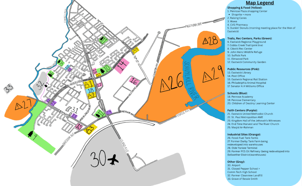
Eastwick Resource Map
This Community Map designed in partnership with Eastwick residents highlights local resources and greenspace as well as nearby industrial sites and pollution sources.
Local Air Quality and Pollution
Eastwick has been affected by pollution from local industrial sites for generations. Air pollution can enter your body and cause health issues, especially for children, elders, outdoor workers and people with underlying health conditions, like asthma. To learn more about the polluting sources closest to you, visit Clean Air Council’s Pollution Tracker here.
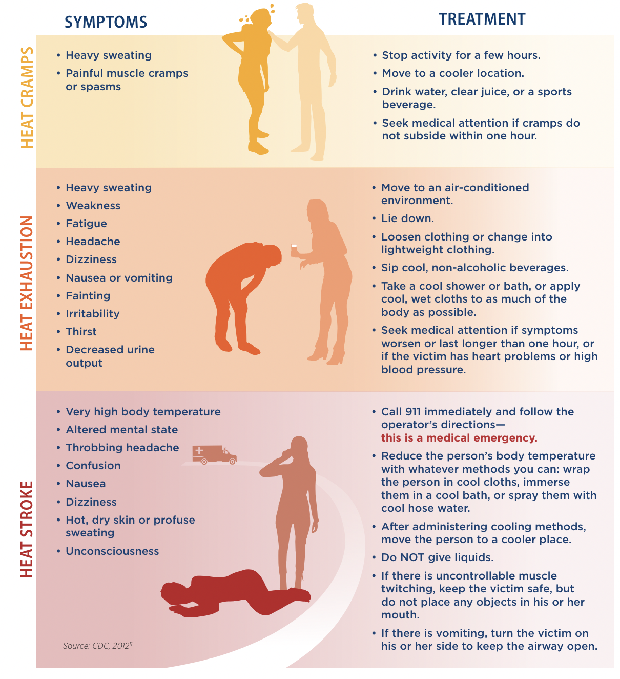
During poor air quality events you may experience symptoms like: Irritation, itching, swelling & watering of the eyes, irritation of the nose and throat, trouble breathing and chest tightness, coughing and wheezing, headaches and dizziness, and fatigue
To stay safe during poor air quality events you can: Check the weather and air quality daily, avoid the outdoors if possible, wear K95 or N95 Mask outdoors, keep inhalers and other medicine with you, stay well hydrated, use indoor air filters, close car windows and set AC to recirculate, and seek medical care if needed.
Clean Air Council has installed air monitors across South and Southwest Philly because air quality can vary between neighborhoods across the City due to local hazards. To see the current air quality in Eastwick visit the Purple Air Map here.
Eastwick Flood Risk:
Why does Eastwick Flood?
Eastwick has a much higher risk of flooding than other parts of the city due to its location near the Darby Creek, Cobbs Creek, Schuylkill and Delaware Rivers. Eastwick has already been affected by many significant storm events, including Hurricane Floyd and Tropical Storm Isaias. As global warming causes sea levels to rise, communities along tidal rivers, like the Delaware and Schuylkill, are more likely to flood.
Flood Preparedness:
These are a few steps you can take to be prepared ahead of a flood event including:
1. You can put your address into this Pennsylvania Flood Risk Map to view how likely your area is to flood.
2. Review the City of Philadelphia’s “Eastwick Resident’s Guide to a Flood Ready Home” This guide further explains the types of flooding that uniquely affect Eastwick, how to prepare your home based on its design and features, and includes strategies to reduce risk, damage, and insurance premiums in the event of a flood.
3. Secure flood insurance and check on your flood insurance policy annually
4. Connect with local neighbors and community groups like Eastwick Friends and Neighbors Coalition and Eastwick United CDC. Sharing resources with neighbors and establishing connections across the neighborhood now makes it easier for neighbors to work together and help one another when flood events do occur.
Restoring Shade and Filtering Air the Natural Way
Greenspace like parks, trails, and trees help to cool the neighborhood and reduce the impacts of rising temperatures and air pollution. Using these resources you can apply for a free yard or street tree to help bring more shade to your block:
Get a Tree | Pennsylvania Horticultural Society
Request street tree maintenance: Tree-Related Services | City of PhiladelphiaBecome a volunteer Tree Tender to plant trees in your community, and join your neighborhood group: Tree Tenders Program | Pennsylvania Horticultural Society and Find a Tree Tenders Group Near Me