By Teresa Hong and Alexander Chong – Clean Air Council Bridging the Gap Drexel University Interns
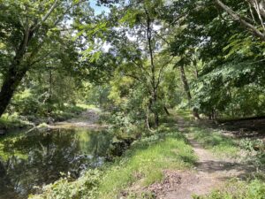
As we wrapped up our assessment of Cobbs Creek Trail this summer, one thing became clear: this trail is more than a pathway through green space—it’s a lifeline that has long connected communities, memories, and meaning. In conversations with residents, we unearthed stories that revealed just how deeply rooted Cobbs Creek is in the neighborhood’s history.
The Cobbs Creek Trail bridge wasn’t just a way to cross the creek; it was a meeting point, a playground, a boundary-breaker. Learning about the racial covenants that once segregated Philadelphia neighborhoods was both eye-opening and sobering. Yet hearing how kids from different backgrounds used to gather, play, and build friendships along the trail painted a more hopeful picture. The open space by the creek served as a backdrop for celebrations, community events, and everyday joy. The smiles on residents’ faces as they recounted those memories spoke volumes. Those stories reminded us that trail maintenance isn’t just about physical upkeep—it’s about preserving legacy.
Throughout this summer, we documented many of the issues affecting Cobbs Creek Trail, but it’s clear that our work is only the beginning. Our data reflects what residents already know: the current state of maintenance falls far short of what this community deserves. While the trail offers natural beauty and expansive greenery, its deteriorating infrastructure and lack of safety features deter the very people it’s meant to serve.
Safety and accessibility, in line with Clean Air Council’s mission, are the most urgent needs. Trails, no matter how scenic, are underutilized when they feel unsafe. Damaged and unrepaired guardrails—likely from past car crashes—send a silent but powerful message: that community safety is not a priority. Residents echoed this concern, noting how such neglect discourages trail use and adds to a sense of abandonment.
Beyond safety, we observed serious wear and tear on user-facing infrastructure like benches, picnic tables, and playground equipment. Many of these were overgrown, rusted, or broken—no longer inviting or even functional. In some spots, erosion, and water damage affected roads, sidewalks, and curbs, creating significant accessibility barriers, particularly for individuals with disabilities. A truly inclusive trail must be navigable and welcoming to all.
Being part of the Trail Maintenance Team taught us that trail care isn’t just about fixing what’s broken—it’s about preventing things from breaking in the first place. Deferred maintenance doesn’t just delay enjoyment; it increases future costs and compounds community frustration. One lesson that stuck with us came from a mother who pointed out a broken swing seat that had remained unusable for months. “A new park is nice,” she said, “but it means nothing if it’s not usable.” We agreed—and made it a priority to document and report the issue through 311, fulfilling a promise we made to her and ourselves.
Of all the work we did this summer, our conversations with residents were the most impactful. They helped us understand the deeper significance of our task. For many, seeing Cobbs Creek in its current condition is heartbreaking—not just because of what’s broken, but because their children no longer experience the same joy and freedom they once did. Trail maintenance, we realized, is not just a technical issue. It’s a community issue. It’s about restoring trust, honoring history, and fostering a healthier future.
Ultimately, a well-maintained trail is a public health investment. It invites families out of their homes, promotes physical activity, and creates shared space for joy, rest, and connection. We hope our efforts help bring renewed attention to Cobbs Creek Trail and serve as a spark for long-overdue investment in this vital space. The trail has carried stories for generations—now, it’s time to care for it in return.
By Teresa Hong and Alexander Chong – Clean Air Council Bridging the Gap Drexel University Interns
Environmental justice is undeniably an important social determinant of health. As medical students, we recognize that where people live and the resources they can access have a direct impact on their physical and mental well-being. To better understand how these factors play out in the community we serve, we spent a summer working with the Clean Air Council, focusing on an often overlooked resource in Philadelphia: trails.
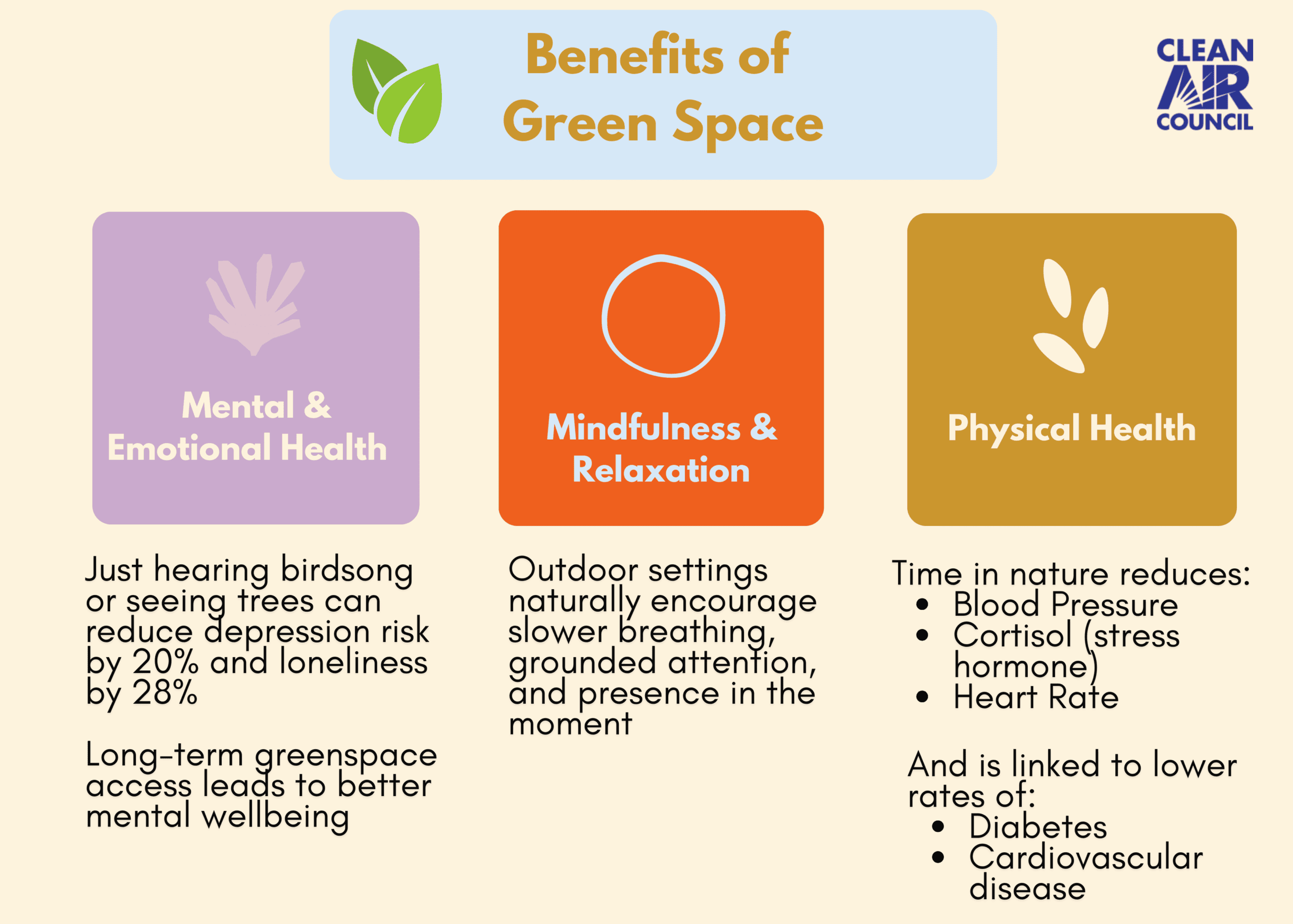
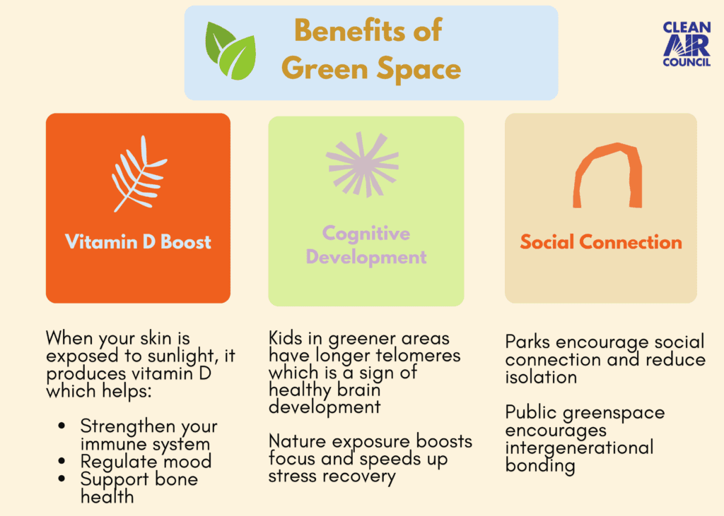
Our project centered on supporting trail longevity using a new mobile app called the Trail Maintenance Toolkit (TMT). This app, developed by the Pennsylvania Environmental Council, allows users to document, assess, and geolocate trail infrastructure, from benches and lighting to drainage features and debris. Our focus was the Cobbs Creek Trail, an area that is both underserved and historically underfunded. Trails like Cobbs Creek are more than recreational paths; they’re vital community assets. Everyone deserves access to safe, well-maintained green space. In fact, access to green space has been linked to lower rates of diabetes, heart disease, and even premature death. These are chronic conditions that disproportionately affect Philadelphians. In this way, trails like Cobbs Creek can serve as preventative medicine, especially in neighborhoods with limited health resources.
At first, the work of documenting the trail was a bit daunting. We were unfamiliar with terms like inlets, which direct water off the path, and bollards, which block unauthorized vehicles from entering pedestrian areas. We had never walked the full trail before, and we weren’t sure what to expect. But the app quickly proved to be intuitive and well-organized. Using geolocation, we could drop points of interest directly onto the trail map and categorize them by type and condition.
The main categories for points of interest include:
| Trail surface | Trail amenities | Drainage features | Debris | Trail support |
| Trail structure | Signage | Vegetation Management | Environmental concerns | Trail crossings |
Each category is color-coded and can be broken down into subcategories. For example, “Trail amenities” includes:
| Benches | Litter receptacles | Bike racks | Bike repair stations | Lighting |
| Picnic tables | Other seating | Drinking fountains | Bollards | Other |
Each point also includes notes, condition ratings, photos, and the suspected source of any damage. You can also attach files or add more detailed descriptions. The webinar has a good breakdown for categorizing the condition of assets.
One thing we quickly learned was that it’s easy to overlook features when you’re not actively looking. Early on, we only recorded things that were broken or needed repair. But we realized that documenting well-maintained structures—bike racks, benches, light poles—was just as important. A full picture of trail health includes the good as well as the bad. We aimed for full completion, hoping to record every visible trail detail, no matter how small. It became both a learning process and a deeply rewarding one.
The TMT helped us see the trail differently. We began to notice swales, which are shallow, vegetated channels that manage water flow, and subtle erosion on the trail surface. We spotted features like signage and drainage systems that had gone unnoticed before. What once felt like a walk in the park became a meaningful exploration of urban infrastructure, public health, and community investment.
By the end of the project, we were proud of what we had contributed. Our documentation will inform real maintenance and improvement efforts, helping ensure Cobbs Creek Trail remains safe and accessible for years to come. But beyond that, the experience gave us a deeper appreciation for how environmental justice intersects with healthcare. The Trail Maintenance Toolkit has real potential to create positive change in the Cobbs Creek community, and we are proud to have played a part in that process.
By Teresa Hong and Alexander Chong – Clean Air Council Bridging the Gap Drexel University Interns
“Today, maintaining existing trails is equally as important as building new trails.”
That quote from the Pennsylvania Environmental Council’s (PEC) trail sustainability page hits on an often-overlooked truth: trails need regular care. Sustainability isn’t just about new growth—but also about upkeep.
In its Trail Maintenance Resource Guide, PEC illustrates why trail sustainability and maintenance are so important. A lot of energy goes into building trails and parks—budgeting, planning, construction—but over time, those features wear down. Keeping trails in usable condition takes ongoing effort. Think of it like a daily shower—sometimes you just need a rinse to feel refreshed. And who doesn’t feel better after a clean-up?
When trails are neglected, issues pile up. Degraded trail paths, worn-down amenities, and broken safety features all need attention to keep trails maintained, or even improve it. Smaller maintenance issues like broken lights impact safety and vandalized signs can prevent vital information. Natural debris or blockages can make sections of trail inaccessible, especially wheelchair-accessible paths.
Taking care of these problems early can help keep costs low for the city and its taxpayers. It’s much cheaper to maintain a trail than to tear down a worn-out structure and start over. Good maintenance also helps prevent damage to nearby infrastructure, like roads or buildings by preventing spillover. But to preserve and maintain, you need a good system of documentation for track trail quality, logging changes to quality and reporting to let staff know of issues. Which introduces PEC’s new trail maintenance system.
Because public resources for trails are often limited, PEC developed a new tool called the Trail Maintenance Toolkit (TMT). This toolkit is designed to help document and categorize park trails and structures. It’s a great starting point for trail upkeep.
We first learned about the TMT through a webinar on PEC’s trail sustainability page. It turned out to be a great introduction for understanding the mindset behind the tool. A lot of positive repairs have happened on trails, and this tool is a way to monitor trails qualities and assets. For further insights on the TMT, PEC offers an online trail assessment guide, a podcast episode, and a recorded version of the Trail Maintenance Webinar on their YouTube channel. For us, getting into the rhythm of upkeep and learning the language of documentation really helped get us in the right headspace for trail maintenance.
Using the TMT on site, we became obsessed with data collection. Like a new video game, we did not want to leave any stone unturned. We would often go up and down the trail trying to consistently document resources and assessments, knowing this data may be important for regular maintenance of the trail. Knowing that we made an impact has made all the difference.
The TMT will soon be publicly available online on the web and mobile app!
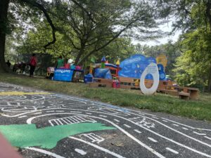
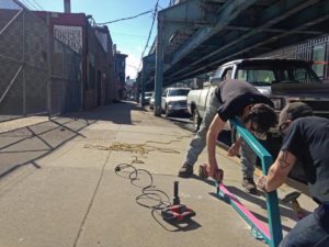
Clean Air Council is thrilled to announce the installation of the Cobbs Creek Park and Trail Playful Learning installations. With the financial support of KABOOM! and William Penn Foundation’s Play Everywhere Philly Challenge grant, four installations that span almost two miles across Cobbs Creek Park offer opportunities for different neighborhoods to connect to green space at the safe crossing location closest to them.
The project locations along Cobbs Creek Trail at Cedar Ave, 61st St, Thomas Ave, and Florence Ave encourage residents to explore playful learning sites that include both asphalt art murals on the ground and vertical play learning structures. In addition, the project connects the locations through maps to encourage residents to explore playful learning sites throughout the park. This project brings learning and play opportunities that center around nature and community history to draw residents into green space at safe crossing locations along Cobbs Creek Parkway, and invites residents to explore Cobbs Creek Park and Trail.
The Council is excited to see neighbors and stakeholders interacting with the Playful Learning installations over the last three months and incorporating them into weekly walks and regular programming. A big thanks to all of the residents and team of community stakeholders, including Cobbs Creek Community Environmental Center, Cobbs Creek Neighbors, and Southwest CDC, who helped advise the project and provided input and feedback to inform the project’s design and locations. Thanks also to the design teamat Tiny WPA and Amber Arts and Design for their dedicated efforts in bringing this project to fruition.
The Council’s GoPhillyGo trip planner is the best way to get car-free multimodal directions in the Philadelphia region. Now, the new GoPhillyGo “Tours” section allows users to navigate between three or more destinations that are close in proximity or share a common theme.
For example, when you plan a trip to Wissahickon Valley Park, use the premade tour to navigate from the Toleration Statue to the Fingerspan Bridge, then to the Valley Green Inn for a bite to eat along the creek. Use “Tours” to find gateways and trailheads for regional greenways like the Schuylkill River Trail, Cobbs Creek Trail, and Tacony Creek Trail.
Mobile sources are the number one source of air pollution in the Philadelphia region, and each time you plan a car free trip on GoPhillyGo, you are doing your part to reduce air pollution . Double down on your commitment to sustainability and check out the new “Tours” section on GoPhillyGo.
For more information on the Council’s GoPhillyGo program email Ptah Gabrie at pgabrie@cleanair.org
You may have heard that for the month of October, we, along with GoPhillyGo, Indego, and the Bicycle Coalition of Greater Philadelphia, will be celebrating bicycling across Philadelphia with the Love to Ride (LTR) Challenge, a fun, friendly, and free competition to get more people cycling. Increasing bicycling for daily travel is one of the primary goals of our work towards improving air quality in the region. Two of the common cited barriers to cycling include safety and riding, as in knowing where to ride or having other people to ride with. We seek to address these issues by increasing cycling infrastructure, making bicycle trip-planning easy, and advocating for safe streets for all. Read on to learn about our expansive work on bicycle infrastructure, education and advocacy.
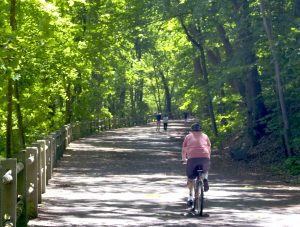
Multi-use Trails
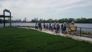
 We are a proud member of the Circuit Coalition – a group of non-profit organizations, municipalities, and government agencies that are working together to complete the region’s goal of 750 miles of connected multi-use trails. Currently, the Circuit Trails has over 300 miles complete, with about 100 more miles in progress. We are the lead on some of those in progress miles, including the Cobbs Creek Connector Trail and the Heinz Refuge bike/pedestrian connections.
Cobbs Creek Connector Trail
The Cobbs Creek Connector Trail will help complete the Cobbs Creek Trail, a key segment of the East Coast Greenway, and will be an important link between communities to recreational areas and historic sites, like John Heinz Wildlife Refuge at Tinicum (JHNWR), commercial hubs and employment centers. The Connector Trail will run approximately 3 miles from Cobbs Creek Trail’s current southern terminus to the JHNWR, spanning 4 main sections. Click here to learn more about the 4 sections of the Cobbs Creek Connector Trail.
Heinz Refuge Bike/Pedestrian Connections
We are partnering with JHNWR to build 3 additional pedestrian and bicycle friendly links in Philadelphia and Delaware Counties to JHNWR and businesses in the vicinity, including Philadelphia International Airport. Click here to learn more about these 3 connections.
Bike Racks
 Secure bike parking is one of the deciding factors on whether a person bikes to work or not. We recognized this several years ago, and since then have been helping businesses with the on-street bike rack permitting and installation process.
In 2016, we took on a new (to us) bike rack endeavor – the art rack. We were funded by the Penn Treaty Special Services District and the American Street Empowerment Zone to create and install 15 art racks as well as 10 standard inverted-U bike rack and a bike corral in the Fishtown, Kensington, and Northern Liberties neighborhoods. Art racks not only provide secure bike parking to employees and customers of businesses in these neighborhoods, but they also provide an appealing aesthetic that is as much place making as it is bike parking. These have been created by a local metal worker and have been an exciting asset to add to these neighborhoods.
As an extension of our work with bike racks, the Council was awarded an Azavea Summer of Maps fellow, who helped us analyze where bike racks already exist, how much they are being used, where illegal bike parking is happening, and ultimately design a way to predict how many bike parking spaces per employee or customer are needed in different situations.
Do you know a business that is interested in implementing secure bike parking? Have them contact Will Fraser, Sustainable Transportation Outreach Coordinator, by calling 215-567-4004 ext. 123 or emailing wfraser@cleanair.org.
GoPhillyGo
 GoPhillyGo.org is the region’s multimodal trip planner that we created to help make it easier to get around the Greater Philadelphia Area without a car. The website lets users plan biking, walking, public transit directions, or any combination of those modes of travel. GoPhillyGo also gives users the option to make their bike trip flatter, faster, or safer by using the customizable options. A very exciting new addition to the website is the Indego bike share functionality. Not only can you check individual station’s dock availability, but now you can plan a trip from start to end with seamless directions of which station to walk to, how to bike to the end station,you’re your final walking leg, just like taking transit!
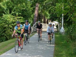
As part of GoPhillyGo, we organize bike rides for cyclists of all abilities to environmental centers and nature destinations. Just recently we explored the new Bartram’s Mile, a multi-use trail that goes through Bartram’s Garden, by bike. Subscribe GoPhillyGo’s eNewsletter to stay-up-to-date on our bike rides.
Vision Zero
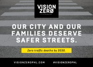 Finally, one of the most important ways we are working in Philadelphia as an advocate for bicycling is through the Vision Zero Alliance and the city’s subcommittees for Vision Zero. Vision Zero is the approach to traffic safety, first implemented in Sweden, based on the notion that no traffic death is acceptable. Cities that adopt Vision Zero policies have the goal of reducing traffic deaths to zero, and Philadelphia recently established their policy, with a goal of eliminating traffic deaths by 2030. The Council works with the City and other advocates to help this goal be met. In addition to Vision Zero’s importance for the dignity of all road users, there is a clear environmental relationship: as the most vulnerable of roadways users, people will not walk or bike for transportation if it isn’t safe.
What’s Next
Until we reach our Vision Zero goal of zero traffic fatalities and serious injuries, there will be crashes. While many major crashes are reported to police, there are many that are not. Soon we will be debuting a a web tool for reporting minor crashes and close calls. This data can help the City identify areas where improvements for road safety are needed. Remember to always report a crash that results in an injury serious enough to involve medical attention. But, for something minor, help us keep track of when and where those events are happening – stay tuned for Close Calls Philly.

GoPhillyGo.org, the free online mapping site for the greater Philadelphia area from Clean Air Council, has now released a mobile version for use on all mobile devices. Designed to make getting around without a car both easy and fun, the power of GoPhillyGo’s mapping technology will now be available on the go. You’ll be able to take the ultimate trip-planning tool for biking, walking and public transit with you—anywhere you go, any time you need it.
Developed with state-of-the-art open-source mapping technology from Philadelphia-based geospatial technology firm Azavea, GoPhillyGo makes it easy to plan a route through multimodal methods — combining biking, walking, and public transportation within one trip — to go anywhere within the greater Philadelphia area, its surrounding counties, and even into New Jersey without the use of a car. It provides details on pedestrian and bike routes and, on the bike segment of your trip, you can prioritize routes that are faster, flatter, or safer.
“Using GoPhillyGo on your mobile phone is a very exciting advancement for the website,” says Joe Minott, Executive Director of the Clean Air Council. “Obviously that is how so many people are accessing transportation information today, and I’m excited that planning non-car trips just became easier for people in Southeastern Pennsylvania. GoPhillyGo users can now explore some of the region’s most interesting nature-oriented destinations and quickly plan how they’ll get there on bike, foot, public transportation, or any combination.”
The new version of the website comes equipped with mobile functionality, a new look and sleek features, including drag-and-drop locations. Different modes of transport in your route now show up in different colors.
“Incorporating Indego bike share is the other big advancement we are excited about,” explains Nick Rogers, Transportation Program Director for the Clean Air Council. “This really makes planning trips with bike share much easier, and encourages people to use Indego as a transportation mode and not just a recreation activity.” Point-to-point Indego directions, dock locations, and bike availability are now included in the map, helping you get around by bike, even if you don’t own one.
“As a Philadelphia company dedicated to a positive civic and social impact, Azavea is thrilled to partner with the Clean Air Council to promote walking, biking, and riding public transit to our local institutions, parks, and other natural resources,” says Robert Cheetham of Azavea. “Now that GoPhillyGo has gone mobile, anyone in Philadelphia can easily explore the variety of destinations accessible to them. As a company full of bike enthusiasts, we are especially excited about the inclusion of Indego bike share locations into GoPhillyGo biking directions.”
Now, with GoPhillyGo mobile, you can get out of your house and just go. Covering five counties—including Philadelphia—and parts of New Jersey, the new mobile site allows you to plan ahead and take your route with you, change your plans on the fly, or figure it out as you go for a truly spontaneous adventure. Confidently explore Philadelphia; no car needed.
GoPhillyGo.org. Your destination ahead. Your map to getting there.
Clean Air Council is a member-supported, nonprofit environmental organization dedicated to protecting everyone’s right to breathe clean air. The Council has over 8,000 members and works in Pennsylvania, Delaware, and New Jersey on public education, community advocacy, and legal oversight and enforcement of environmental laws.
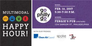
You’re invited to join GoPhillyGo, SPOKE magazine, and Firth & Wilson Transport Cycles on Thursday, February 16 for a multimodal happy hour upstairs at Fergie’s Pub (1214 Sansom St). Philadelphia is fast becoming one of the leading cities in the U.S. to get around without a car, and it just keeps getting better. You’ll hear about an exciting new aspect of GoPhillyGo.org that’s being launched soon, news and plans for the coming year, and you’ll meet up with friends and other multimodal transportation advocates.
RSVP on Eventbrite and join the Multimodal Happy Hour Facebook event page to stay up to date.
We hope to see you there!
What:
Multimodal Transportation Happy Hour hosted by GoPhillyGo, SPOKE magazine, and Firth & Wilson Transport Cycles
When:
Thursday, February 16, 5:30 pm – 7:30 pm
Where:
2nd Floor
1214 Sansom St., Philadelphia, PA 19107
Plan your multimodal trip with GoPhillyGo.org!
Cost:
Admission is free, finger food is free, and drinks are pay as you go. First 50 people in the door will receive a free drink ticket.
About the Organizations
GoPhillyGo is a free online mapping tool for the Greater Philadelphia area, with a major upgrade coming in 2017. Developed with state-of-the-art mapping technology, this site makes it easy for users to plan their routes through multimodal methods — combining biking + walking + public transportation within one trip — to go anywhere within the Greater Philadelphia area without the use of a car. It even provides details on pedestrian and bike routes, letting users customize their trips. Go to www.gophillygo.org to plan your trip today and connect with GoPhillyGo on Facebook or on Twitter and Instagram at @go_philly_go.
SPOKE magazine informs and engages greater Philadelphia by covering mobility. With a focus on long-form journalism and storytelling, the magazine examines urban life through the lenses of bicycling, walking and mass transit. Go to www.spokemag.bike to read SPOKE magazine today and connect with SPOKE magazine on Facebook or on Twitter and Instagram at @spoke_mag.
Firth & Wilson Transport Cycles is a full-service bicycle shop and retail showroom specializing in transportation and cargo bicycles. Now located at 1105 Frankford Avenue, the shop caters exclusively to the urban cyclist with a full range of bike accessories and bicycles from Yuba, Xtracycle, Babboe, Gazelle, Larry Vs Harry, Pashley, Simcoe, Breezer, Linus, Pure Fix, Pure City, SE, and Torker. The option of a custom fabricated bicycle is also on offer, designed by the shop’s owners under the labels David Wilson Industries (DWI) custom cargo bikes and Hanford Cycles custom frames. Go to www.transportcycle.com for more information, and connect with them on Facebook or on Twitter and Instagram at @transportcycles.
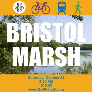
Get multimodal with GoPhillyGo on Saturday, October 22, as we combine SEPTA Regional Rail with bicycling to travel from Center City to Bristol Marsh, a GoPhillyGo featured destination, for an afternoon of bike exploration and nature walking.
We will begin the day at Suburban Station (16th St. & JFK Blvd) by taking our bikes on a reserved SEPTA Regional Rail car at 9:45 am to the Bristol Station. From there, we will bike-explore 15 miles of the Delaware and Lehigh Canal Towpath (D&L Trail). The D&L Trail, now part of the East Coast Greenway’s 3,000 mile bike-pedestrian trail from Maine to Florida, was once a major shipping route during the Industrial Revolution. This is no-drop, leisurely paced ride (10 – 12 mph).
After the ride, we’ll break for a complimentary lunch at Bristol Marsh. Lunch will be followed by a Heritage Conservancy-led nature walk through Bristol Marsh. Heritage Conservancy works as a local partner to The Nature Conservancy to promote the ecological restoration and stewardship of Bristol Marsh. Bristol Marsh is one of the few remaining freshwater tidal marshes along the Delaware River. It is home to six rare plant species native to the Delaware River Basin. After the nature walk, we will return to Center City at 2:11 pm by a reserved SEPTA Regional Rail car.
The cost of this event is $10*. The $10 covers your SEPTA fare and lunch. This event is limited to 15 participants.
Buy your tickets TODAY!
Go to registration page.
Fill in personal and payment information.
Select Other and enter $10. The $10 is an event fee, it is not a tax-deductible donation.
Under Anything else we should know, enter GoPhillyGo at Bristol Marsh.
Join the Facebook event page to stay up-to-date on the ride!
Registration deadline is Monday, October 17.
Bristol Borough-area residents, and those coming from outside of Center City are welcome to attend. To join the bike-exploration and nature walk, meet us with your bikes at the Bristol Station at 10:20 am. Please email Erika Reinhard at ereinhard@cleanair.org to let us know we should plan to meet you.
This is a self-supported ride, we highly suggest bringing a spare tube and repair kit. All riders must wear a helmet and follow the rules of the road. Please bring a lock to safely secure your bike while we are on the nature walk. We encourage riders to pay attention to the weather forecast and to dress appropriately. We also suggest wearing high visibility clothing and to bring a water bottle and snacks. Use of Indego bike share is not permitted. If you have a dietary restrictions, please contact Erika Reinhard.
*The $10 fee is not a tax-deductible donation.
For more information, please contact Erika Reinhard, Sustainable Transportation Outreach Coordinator, by calling 215-567-4004 ext. 111 or emailing ereinhard@cleanair.org.
June is such a happy month for so many reasons. It marks warmer weather and sunnier days, which sets the perfect tone considering it’s also National Trails Month. There’s nothing quite like spending a beautiful summer day outdoors running, walking, or biking on any of the nation’s 60,000 miles of trails that exist throughout all 50 states. Right here in the Greater Philadelphia area, The Circuit is the main trail network. Eventually stretching 750 miles, The Circuit Trails are comprised of many existing trails (and many proposed trails coming in the future) for everyone to enjoy.
The Circuit will connect communities in and around the Philadelphia area to environmental destinations, which will provide endless recreational opportunities. However, as National Trails Month winds down, we thought commuters should know that these trails can work for their busy 9 to 5 schedule, too – by connecting people to public transportation.
The region’s public transit network is crucial for Center City to be able to provide 42% of all jobs in Philadelphia. According to Center City Reports: Getting to Work: Transit, Density & Opportunity, if all 295,000 downtown employees drove into work every day, Center City would need a parking lot spanning 2.6 miles. This is larger than William Penn’s original plan for the city, and would leave little space for the diverse array of downtown employment opportunities that exist today.
Over the last few decades, Center City has developed into the prosperous, fast paced business district that it is today, containing a whopping 295,000 jobs. With help from the city’s existing public transit network, the nearly 245,000 workers who commute in from outside Philadelphia have the option to enjoy a relaxing train ride instead of sitting in stressful bumper to bumper highway traffic.
While it’s easy for some commuters to hop on public transit out of Center City to get home after a long day, it’s not as easy for some to use public transit to get to and from work. Many train stations are geographically isolated from residential areas, making it nearly impossible for commuters to safely access them from their homes without the use of a car.
The Delaware Valley Regional Planning Commission (DVRPC) works to identify candidate SEPTA stations for bicycle friendly investments using a screening tool called RideScore, which works into SEPTA’s Cycle-Transit Plan. RideScore helps SEPTA, trail advocacy groups, and surrounding municipalities understand each station’s characteristics that influence how bike friendly it is. One way SEPTA can use this information is to prioritize bicycle rack installation at specific stations to strengthen bicycle and transit connectivity throughout the region.
Manayunk Station on the Manayunk/Norristown Line, for example, received an average RideScore of 9.3 out of 10. This is in part due to very high “Connectivity” (walkability), “Circuit Proximity,” and “Near Bicycle Facility” (on-road facilities, such as bike lanes) scores. Stations with high RideScores, like Manayunk, make it easier than ever for commuters to safely bike from home on the trail, park their bicycle, and then hop on the train to work.
Not only do trails make it easier for commuters to access public transit without the use of a car, they also offer a variety of other benefits, including:
Increased Workplace Productivity
Engaging in moderate exercise balances the brain’s neurotransmitters, which control mental activity linked to mood, attention, motivation, and the ability to retain information. Bicycling or briskly walking from home to public transit in the morning can help the brain and body cope better with stress throughout the day, which is particularly good for commuters who work in high-pressure environments.
Saved Time
According to INRIX, a leading traffic intelligence provider, the worst bottleneck in the Greater Philadelphia area is the Schuylkill Expressway eastbound at the South Street/Exit 346, where the average car speed when this area is congested is a slow 18.9 mph. By using trails in conjunction with public transit, commuters will avoid wasting time sitting in rush hour traffic.
Saved Money
It’s estimated that the average Philadelphia driver spends $2,300 in wasted time, general car maintenance, and gasoline yearly. In comparison, the average annual operating cost of a bicycle is only $308, and walking is free! Also, many employers offer RideECO, which allows employees to save money by using pre-tax dollars to pay for their commute. Using the region’s multi-use trails on foot or on bike to access public transit will save commuters more money to spend on things like happy hours and vacations.
With all of these benefits, you might want to check out existing and proposed trails in your community on The Circuit’s Trail Finder. And if you are interested in combining cycling with public transportation as part of your commute or just for discovering new places to recreate, check out GoPhillyGo.org. Hopefully by now you’ve celebrated National Trails Month, but if not – or you want to continue the celebration all summer – consider working a trail into your public transit commute!
If you have any questions, please contact Alyssa Geoghan, Sustainable Transportation Outreach Coordinator, by calling 215-567-4004 ext. 120 or emailing ageoghan@cleanair.org.