
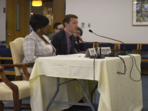
Clean Air Council Transportation Program Director Nick Zuwiala-Rogers spoke at a policy hearing held to address the rising numbers of vehicle related pedestrian deaths and injuries. Senator Sabatina’s district surrounds part of Roosevelt Boulevard which is regarded as one of the most dangerous roads in the country. Read our full testimony below.
(Philadelphia, PA–April 5, 2019)–Thank you for the opportunity to present testimony on behalf of Clean Air Council today. My name is Nick Zuwiala-Rogers and I am the Transportation Program Director at Clean Air Council. Clean Air Council sponsors Philadelphia’s pedestrian advocacy organization, Feet First Philly. The Council and Feet First Philly are members of the Vision Zero Alliance, a diverse coalition working to reduce traffic deaths to zero.
The Council is a member supported environmental advocacy organization whose mission is to protect everyone’s right to a healthy environment. Because transportation is the leading contributor of greenhouse gas emissions, the Council has a major focus on promoting sustainable forms of transportation, including walking. Feet First Philly works to promote walking as a form of transportation and recreation, protect the rights of pedestrians, and improve the pedestrian experience in Philadelphia.
News reports from earlier this year showed that pedestrian deaths in Pennsylvania were up 41% in the first half of 2018 over the same period in 2017, raising widespread concerns. While this trend is alarming, a lack of pedestrian safety is nothing new. Based on the last 5 years of publicly available crash data, pedestrians are 4-5 times as likely to be killed in a crash than non-pedestrians. On state roads, this increases to 6.5 times as likely for pedestrians to die in crashes. While state roads and local roads make up about the same number of crashes involving pedestrians, 75% of the ones that result in a fatal injury are on state roads. I say this to highlight the importance of the state taking a lead role in ensuring pedestrian safety. Local municipalities like Harrisburg, Bethlehem, and Philadelphia are engaging in Vision Zero policies, and the state should be a leader in these initiatives. This statistic also highlights that the most dangerous places to walk are the arterials that connect people to jobs, commercial corridors, healthcare, and public transit options. These state roads that are so critical to mobility are the same ones that are engineered with cars in mind first, and often provide no safe way for people to walk. This presents a clear and unfortunate equity issue where the lives of those who cannot afford a car matter less.
It is fitting we are holding this hearing in Northeast Philadelphia, not far from Roosevelt Boulevard, one of the deadliest roads in the country, which has been unfortunately referred to as “the Boulevard of death.” Roughly one person dies on this road every month, and about half of those people are pedestrians. On this road, last year, the state voted to allow an automated speed enforcement pilot in order to decrease the loss of life here. Expanded use of automated enforcement techniques, including for running red lights and speeding, are some of the tenants of Vision Zero that have worked well in other places. Vision Zero is the concept that fatalities as a result of traffic violence are avoidable, and none should be acceptable. The policy focuses on reducing traffic deaths to zero, with a focus on the most vulnerable road users – pedestrians.
Another tenant of Vision Zero is how we engineer our roads. Being a pedestrian can be a daunting experience, particularly on state roads where pedestrians are so much more likely to be killed. These roadways are clearly designed for cars not people, which is fundamentally wrong in my opinion, and I will guide you through the pedestrian experience walking in Pennsylvania. Being a pedestrian on a state road means you likely will not have a safe space to walk, like a sidewalk. Instead, you might be walking directly beside cars traveling at high rates of speed that will kill you in the event of human error. Even if you do have a sidewalk, you might have to walk up to a mile to the nearest safe crossing. When you get there, there may or may not be a crosswalk. If there is one, there is a good chance it is blocked by a parked car, or a car who did not stop behind the stop bar, as is the norm. When you get the opportunity to cross in that crosswalk, you will now be competing with turning cars who will race to get through the intersection before you have a chance to establish your right of way. As you cross a wide arterial road, you will quickly start to run out of time and could be stranded on the median as cars speed by you, if you are lucky enough to find refuge space in the center of the road.
This experience is the result of decades of prioritizing designing roads to maximize how many and how fast we can move cars, and ignoring the safety of actual people. As a legislative body, you should task our state’s DOT with prioritizing safety over throughput – lives saved over moving as many cars as quickly as possible. Sometimes that means we get places a little slower, but that sacrifice means we save lives.
The good news is there are a few bills that are either already introduced, proposed in previous sessions, or soon to be introduced this year that can help to improve pedestrian safety. I will outline four of them here, and the ways they would protect pedestrians. Two of these bills will specifically target two of the most dangerous behaviors identified by PennDOT’s crash data – speed and distracted driving.
RADAR for Local Law Enforcement (previously SB 251) – Simply put, speed kills. A pedestrian hit at 40 mph has a 10% chance to survive. That number increases to 50% at 30 mph, and a pedestrian hit at 20 mph has a 90% chance to live. In the absence of other automated enforcement techniques, radar should be implemented as a minimum way for officers to objectively track speed. Pennsylvania is the only state in the country not to use this basic technology.
Hand Held Ban (HB 37) – Distracted driving is a major cause of pedestrian fatalities in the state, and is one of the most dangerous behaviors according to crash data. Preventing distracted driving from cell phone use is common sense. According to AAA, 85% of people think cell phone use is a threat to safety, and all of our northeast neighbor states have cell phone restrictions. The gravity of the danger cell phone use generates cannot but overstated, we cannot allow drivers to be distracted by these devices while operating on our public roadways any longer.
Vulnerable Highway User Protections (previously HB 1646) – PA has a minimum 4 foot law for passing cyclists, and this bill would put the same protections on pedestrians and other vulnerable road users, and raise the fines where careless driving results in the death of a vulnerable user. Vulnerable road users do not have the same protections as those in a vehicle, including air bags and other safety features. Many parts of the state do not have sidewalks, especially on the particularly dangerous state roads. When pedestrians are not afforded a safe distance when cars pass them, it creates a lack of human dignity and speaks to equity concerns of whose lives matter. An important piece of this legislation is that it considers the principle of Vision Zero that human error is inevitable, and we should control for it.
Protected Pedestrian Plazas and Pedalcycle Lanes (previously HB 1657) – Legislation is needed to allow cities like Philadelphia who are interested in implementing Vision Zero strategies to do so. One of the best ways to protect pedestrians is by installing protected bike lanes, which is often done by using parking as the protection area. This actually has a greater impact on pedestrian safety than bicyclists because it shortens the crossing distance of the road, allow pedestrians a “head start” to establish themselves in the crosswalk before turning cars, and overall calms speeds by narrowing the cartway.
In closing, I want to bring this back to the foundation of the issue, and that is people and their dignity. Everyone at some point is a pedestrian. People – whether, drivers, transit users, pedestrians, children, seniors, people with a disability – however they use the road, should have the dignity to know they can make it to work, or to a family member’s house, or to the store, and back home again without dying, no matter how they are getting to those places. Currently, that is not true for Pennsylvanians who walk in our public spaces. Pedestrian safety cannot wait any longer and requires this legislative body to take action.
Thank you for your time today, and I look forward to working with all of you to move these policies forward.
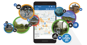
Philadelphia, PA (August 21, 2018) — Since 2015, GoPhillyGo.org has helped people get around the Greater Philadelphia area without a car. Now it’s better than ever with a new app that helps you discover the region.
GoPhillyGo is a project of Clean Air Council and funded by a grant from the William Penn Foundation. The free trip planning site can take you anywhere in the Greater Philadelphia region, including Delaware and New Jersey, without a car. GoPhillyGo gives you directions for biking, walking, taking public transit and is the only multimodal trip planner in the Philadelphia region that allows you to combine any of these modes into one trip.
There are always things to discover in the Philly region, and the new app makes it even easier to find out what’s near you and how to get there. Open the app, and allow GoPhillyGo to use your location to generate a list of nearby places to visit.
Kathryn Killebrew — project technical lead, and Azavea software developer — says “We’re excited to be offering a new GoPhillyGo Android app to complement https://gophillygo.org. You’ll discover fun and surprising things around you, including nature centers and family-friendly events. In building this app, Azavea continues its commitment to contributing open source technology that makes a positive social and environmental impact, and I’m glad to have taken part.”
Turn on Notifications, and the GoPhillyGo app will tell you what destinations are nearby. Users can filter search results by activity type and accessibility. Categories focus on Nature, Exercise, Educational, Cycling, Hiking, and Water Recreation. You can filter for wheelchair accessibility. You can organize your results by tagging them as Been, Want To Go, Not Interested, or Liked. And each destination listing includes the activities you can do there, a map, their website link, and — of course — GoPhillyGo.org’s directions on how to get there without a car. Walk, ride, and bike with the help of GoPhillyGo.
Nick Zuwiala-Rogers of Clean Air Council says “Transportation is the leading cause of greenhouse gas emissions in the U.S., and Clean Air Council is committed to reducing pollution from private vehicles. Our goal is to make it easier to get around without a car, and the GoPhillyGo app is an important part of that effort.”
Take a look for yourself. Screenshots of the app are available here.
The initial release is Android-only, with an iPhone version planned for the future.
GoPhillyGo.org. Your destination ahead. Your map to getting there.
Clean Air Council is a member-supported environmental organization serving the Mid-Atlantic Region. The Council is dedicated to protecting and defending everyone’s right to breathe clean air. The Council works through a broad array of related sustainability and public health initiatives, using public education, community action, government oversight, and enforcement of environmental laws.
PHILADELPHIA, PA (June 4, 2018)- Clean Air Council joined other advocates testifying at City Council in support of the proposed changes to Spruce and Pine Streets in Center City. The project would include protecting intersections and moving the bike lane to the left side of the road where there is a smaller blind spot for drivers. These changes would increase safety and make non-motorized travel along these streets more comfortable and enjoyable. Read the Council’s testimony below to understand why it supports the proposal now, and what it would like to see in the future.
Thank you for the opportunity to present testimony on behalf of Clean Air Council today. My name is Nick Zuwiala-Rogers and I am the Transportation Program Director at Clean Air Council. My work includes promoting sustainable modes of transportation like public transit, walking, and cycling.
Clean Air Council is one of the Philadelphia region’s oldest environmental organizations, serves thousands of members in the city, and has a mission to protect everyone’s right to breathe clean air. The Council supports the proposed project on Spruce and Pine and the associated bills to change parking along these roads, and believes it will help improve air quality in Philadelphia.
According to the U.S. Energy and Information Administration (EIA), the transportation sector has produced more carbon pollution than any other sector since 1979. The EIA has cited the country’s over reliance on single-occupancy vehicle travel and a failure to prioritize non-driving modes of transportation as having a profound impact on this result. Philadelphia needs to do better at prioritizing other modes of transportation like walking, public transportation, and bicycling, and this project offers an opportunity to do that.
Due to the congestion that this City Council has noted recently, center city has some of the worst localized air quality in the city. Therefore, increasing the number of people getting around without using a car should be a priority for this Council. Increasing the safety and comfort of cyclists and pedestrians is the only way to make that happen.
Protected bike lanes are a proven solution for making all road users safer, and getting more people comfortable biking, thereby increasing mode share away from congestion-creating automobiles downtown. A Federal Highway Administration study found 96% of cyclists feel safer riding in a protected bike lane, and safety for cyclists and vehicles improved in nearly every aspect where flex posts or parking protected bike lanes were installed. A physical separation reduces traffic speeds, calms intersections by reducing the turning radius and forcing slower speeds, and creates a shorter crossing distance for pedestrians. I understand that is not what is proposed today, but I should be clear that physical protected bike lanes are ultimately what the Clean Air Council supports.
While this project does not go as far as creating the protected bike lanes that should eventually be installed on these roads, the protections at intersections and the move from right to left side of the street offer key incremental changes that will make road users safer on Pine and Spruce Streets. Importantly, the protected intersections that are a part of this project would help to prevent crashes like the two last year that ended fatally for one person, and with nearly the same result for another. The move to the left side of the road will decrease the space that a cyclist is in a vehicle’s blind spot, especially trucks which are so deadly.
These two roads are the main arterials across center city for cyclists, and are two of the most used bike lanes in the city. The current design is frankly way behind the times and way behind where a city like Philadelphia needs to be with its infrastructure. These safety improvements are not just needed, they are long overdue, and Clean Air Council strongly urges you to support the proposed bills in front of you today.
Thank you for the opportunity to speak with you this afternoon, I’d be happy to take any questions now or discuss any of these matters more with you outside of this meeting.
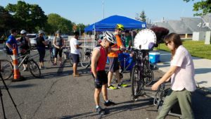
Join Clean Air Council, PIDC, GoPhillyGo, and South Philly Bikes for the Navy Yard’s 2018 Bike to Work Day on Friday, May 18th, 2018 from 7:30 -10:00am. A support station will be located inside the Broad St. Navy Yard gate with free coffee, doughnuts, spin-wheel giveaways, an expert bike mechanic, and tire air for those who need an extra pump for the ride home.
Clean Air Council will have information on commuter benefits and GoPhillyGo will be on site to offer safety tips and help plan your next bike trip in or around Philadelphia. A SEPTA/Navy Yard bus bike rack will be on site to practice how to load your bike all in the comfort of a protected pop up bike lane. Register for Bike to Work Day to pick up a swag bag at eventbrite.
Project overview
Clean Air Council was awarded an Azavea 2017 Summer of Maps fellowship program to better understand the state of Philadelphia’s bicycle parking demand, and pinpoint areas in Center City with limited bicycle parking infrastructure, or where the infrastructure did not meet the demand. The project centered on finding variables that could explain the bike parking demand, using employment data, on road bike facilities, Indego trips, and other data. One of the major goals is to be able to predict bike parking demand in other locations, in order to provide appropriate bike parking infrastructure. Data collected from this study will be used to identify gaps in bike parking, and lay the groundwork for interested investment in safe and secure bike parking.
Philadelphia’s 2013 bike rack study, conducted by the Mayor’s Internship Program, created a baseline for bike parking in Center City. The results of the City’s 2013 study found the number of bikes parked on sidewalks exceeded the existing bike rack capacity. The study also revealed formal bike parking was not being utilized on streets with bike racks. Bike parking exceeded demand in some Center City areas while not satisfying demand in other areas.
Data wrangling
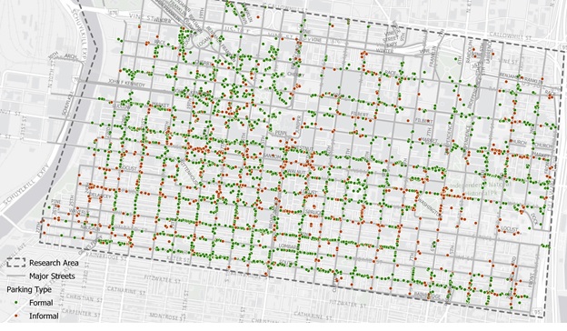
The Council made the most of the opportunity to work with an Azavea fellow with expertise in geospatial data analysis by not only getting in-depth analysis, but also collecting a new round of data. In order to understand the factors that contribute to an area’s bike parking demand, the Council first needed to determine which downtown Philadelphia areas are in most need of bike parking by locating and identifying every existing bike rack in Center City, as well as every bike that is parked in Center City, and whether it is to a rack or another informal structure.
The Council used the Fulcrum app to collect data using cell phones. Staff from Azavea and Clean Air Council used the app to geolocate bikes and bike racks on all streets between the Schuylkill and Delaware Rivers from South Street to Vine Street. Locating formal bike rack parking included differentiating between inverted U/staple racks, bike corrals, and parking meters. The study also documented informal bike parking including bikes locked to railings, trees, poles, scaffolding, and fences. Conflicts that prevented bicycles from correctly locking to a rack, and bike racks appearing damaged or in disrepair were also noted.
The whole process of walking all of center city during daytime, work week hours took 12 staff and volunteers between the two organizations, 6 days, and collected 4,000 data points!
Analysis
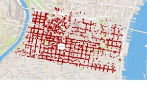
Capturing existing bike parking infrastructure allowed Azavea to provide accurate mapping images of bike parking demand. Azavea’s analysis was based on several data sets ranging from census job data to transit station locations to bicycle trip data.
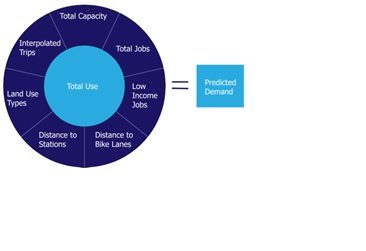
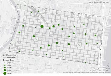
Indego bikeshare’s public data allowed Azavea to look at the number of one-way weekday trips from 7-11am from April through September 2016. This gave a baseline of how many cyclists were travelling to different parts of Center City during work week morning hours. Total number of jobs, in addition to land use, helped identify areas in Center City most likely to host employees commuting by bike. Proximity to bike lanes and distance to train stations were also added factors to the predicted demand equation.
Conclusions
Azavea found a linear regression equation to be the best fit in determining the need for bike parking, while being easy to interpret and able to be written as a formula, Y = β0 + β1X1 + β2X2 + β3X3 + Ɛ. The final list of variables that can be used to predict the demand for bicycle parking include: formal capacity, total jobs, Indego bike trips, commercial consumer land use, commercial business and professional land use, and mixed commercial and residential land use.
In addition to pointing out all over Center City where there is a clear need for increased bike parking infrastructure due to the level of informal bike parking, the model also identifies a few areas that should be looked at more because they show high demand in the model. The study found three areas where eight to ten additional bike parking spaces are needed. These areas include 13th and Market Street around the entrances to the El station, around Liberty Place on Market Street between 17th and 18th Streets and around the department stores near Jefferson Station between Market Street and Filbert Street and from 7th to 10th Streets. The study found the City’s Municipal Services Building, between JFK Boulevard and Arch Street between Broad and 15th Streets, and Jefferson Hospital’s Lubert Plaza between 10th and 11th Streets and between Locust and Walnut Streets to be where bike parking was used the most.
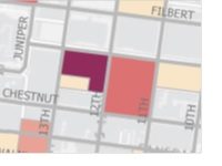
Near 13th Street MFL Station
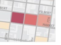
Jefferson Station department stores
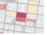
Around Liberty Place
Limitations
This model shows the best correlation between actual use and predicted demand of bike parking, though the model did produce some inaccurate results. In areas shown in dark red, the model over predicted the need for bike parking. In the dark blue areas, the model under predicted demand. It was pointed out by Azavea’s fellow that the census data used was wide in scope for a study as precise as ours. Lastly, the Fulcrum app used to collect bike rack data would sometimes locate racks on the opposite side of the street leading to some inaccuracy.
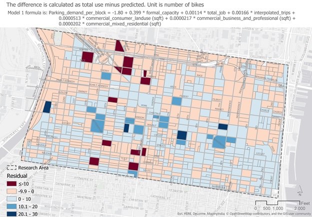
The equation used for this analysis was not tested outside Center City, but the Council hopes to do this in the future. Indego bike trips were used in the final prediction formula making models outside of Indego’s service area inaccurate, but another formula that did not include Indego as a predicting variable was also created so that this could be used in other areas of the city.